Forecast Highs

Temperatures rebound into the 50s to near 60 ahead of a cold front.

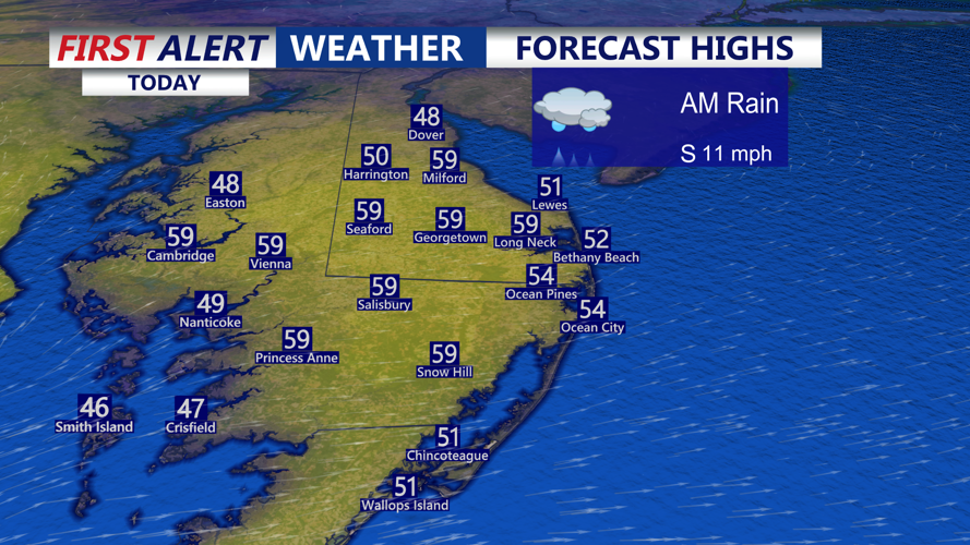
DELMARVA -- After morning rain temperatures bounce back nicely this afternoon into the 50s to near 60 across Delmarva with a mix of sun and clouds. A cold front approaches later today and pushes through this evening, bringing a noticeable shift in the air mass.

Tonight, skies turn partly cloudy and it gets cooler, with lows dropping into the mid to upper 30s to near 40.

Weekend Planner

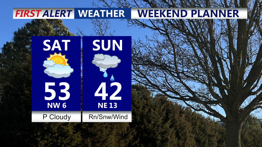
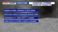
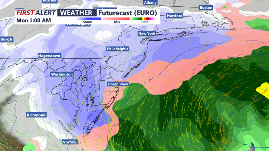
Saturday the pick of the weekend, coastal storm will impact the peninsula Sunday into Monday.

Saturday is the pick of the weekend: partly cloudy, quieter, and seasonably cool with highs in the low 50s. Saturday night into early Sunday is when our attention turns to a strengthening coastal storm potential.

Coastal Storm

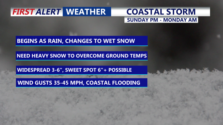
A coastal storm could bring significant impacts to the region Sunday night into Monday morning. 

The likelihood of precipitation continues to increase for Sunday into Monday, with confidence high that Delmarva sees some form of precipitation during this window (roughly an 80 to 90 percent chance). The bigger question is what type and how much, because forecast guidance still shows a wide spread in the possible storm track and strength. It appears all model solutions bring a stronger storm closer to the Mid-Atlantic coastline, which would support heavier precipitation rates, stronger winds, and higher snow totals. 

Futurecast

Rain will transition to heavy wet snow, heavy snowfalls rates will have to overcompensate for warmer ground temperatures. 

 Another key factor is the temperature profile near the ground. The air mass ahead of the storm is not especially cold, so small temperature changes will matter when it comes to rain versus snow and how well snow can accumulate, especially near the immediate coast.

Even if the storm stays more offshore, a strengthening northeast wind is likely Sunday into Monday, particularly for coastal areas, raising concern for at least minor coastal flooding around times of high tide. A stronger, closer storm would increase that flooding risk and could also bring stronger wind gusts.

For now, an early snowfall range is generally 2 to 6 inches across much of Delmarva, but those numbers are still highly uncertain and will likely change as the storm’s track and intensity become clearer. The most important takeaway is to plan for impactful weather Sunday into Monday and keep checking updates.

Behind the storm, colder air settles in Monday and Tuesday with highs mostly in the 30s and lows in the teens and 20s, before a milder trend returns during the second half of next week.


Meteorologist

Chris Mastrobuono is a South Philly native, but has come to join the CoastTV meteorology team. With over three years of experience delivering accurate, passionate and insightful weather analysis, he is eager to report on the coast. Previously, he spent over two years as a morning meteorologist at WEVV CBS/FOX in Evansville, Indiana. 

Meteorologist

Meteorologist Bob Trihy joined CoastTV in 2023. He grew up in Great River on Long Island, N.Y. Bob caught the weather bug when he was around eight years old and tracked storms up and down the east coast. He witnessed some big ones, like the blizzard of 1978, as well as tropical systems.

Recommended for you