


A vigorous low-pressure system lingering over the Mid-Atlantic will continue to influence weather conditions through late Thursday evening into Friday in Sussex County. Winds are expected to strengthen behind the departing low, with peak gusts ranging from 35 to 50 mph as the pressure gradient tightens between the departing system and building high pressure. forecast.weather.gov+1
Tonight into Friday morning, the low is expected to lift northeastward away from the region, allowing skies to clear and winds to shift to the west. Gusts of 30 to 35 mph may continue for several hours before increasing again late Thursday night into Friday with gusts of 40 to 50 mph possible. Friday’s high is forecast to drop into the upper 50s — about 10 degrees cooler than Thursday — with overnight temperatures falling into the low to mid-40s Friday night.
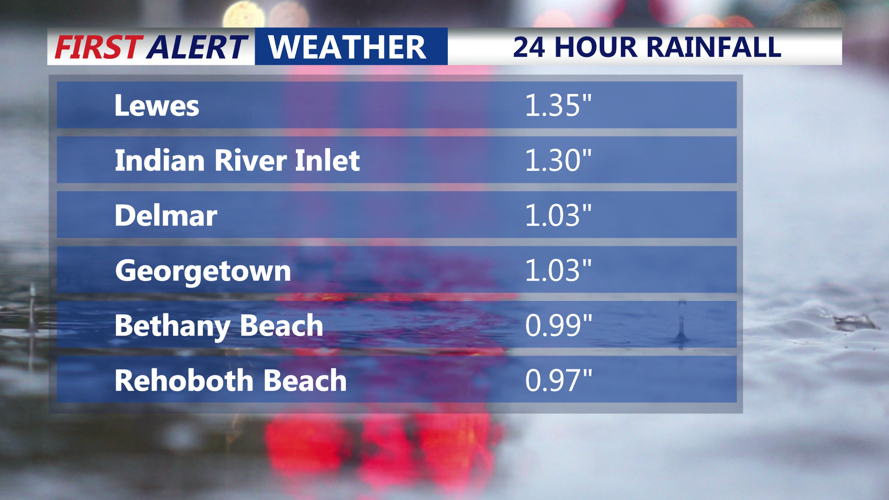
While rainfall tapers off Thursday evening, the stronger concern is wind. The pressure gradient behind the exiting low will result in mixed west-winds at the surface as strong momentum from the 850 mb level mixes down. As a result, a Wind Advisory is anticipated for Friday and Friday evening in the region. Travelers, property managers and residents are advised to secure loose objects and be cautious of downed limbs or power-line hazards.
By the weekend, a shift in the weather pattern will bring high pressure into the region, delivering drier conditions and a general cooling trend. Saturday and Sunday are expected to feature partly cloudy skies with daytime highs in the upper 50s to low 60s and overnight lows in the mid-30s. Looking ahead to early next week, a cold front is forecast to move through Monday night into Tuesday, with another storm system possible heading into Thursday.