


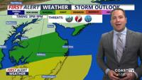
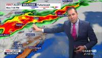
Meteorologist Chris Mastrobuono has the latest on a RED ALERT late this afternoon -evening, ENHANCED risk (3 of 5) for severe storms, damaging…
From
To


Meteorologist Chris Mastrobuono has the latest on a threat for severe storms late this afternoon-evening, damaging winds, isolated tornado, la…

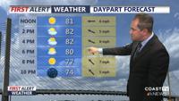
Meteorologist Chris Mastrobuono has details on a spectacular Monday, mostly sunny highs in the low to mid 80s, comfortable humidity levels, Ye…

Meteorologist Chris Mastrobuono has the latest on a muggy day with highs in the upper 70s to low 80s, tracking the threat of heavy rain, flash…

Meteorologist Chris Mastrobuono has the details on a partly sunny muggy day in the upper 70s, low 80s, tracking another severe threat this aft…

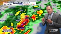
Meteorologist Chris Mastrobuono has the latest on a threat of severe storms late this afternoon through the evening, damaging winds is the pri…

Meteorologist Chris Mastrobuono has the details on the return of heat and humidity, highs in the upper 80s to low 90s under partly sunny skies…

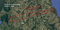
The National Weather Service crews are surveying storm damage across parts of Maryland and Delaware on Monday following reports of strong winds overnight. The survey has so far revealed two tornado confirmations.

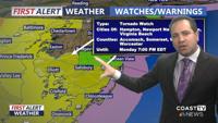
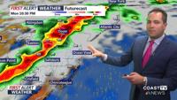
Meteorologist Chris Mastrobuono has the latest on a Tornado Watch for the entire Delmarva peninsula through 7PM, multiple rounds of severe thu…

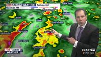
Meteorologist Chris Mastrobuono has the latest on a RED ALERT for a threat of damaging wind gusts in excess of 70 mph and isolated tornadoes t…