


DELMARVA - Sussex County will see a shift in weather beginning early Tuesday as a cold front approaches, eventually ushering in cooler temperatures and breezy conditions by midweek.
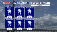
Tuesday morning will start mild and humid, with lows ranging from the upper 50s inland to the mid-60s along the coast. Skies will be mostly cloudy through the day, though most of the area is expected to remain dry. Afternoon highs will climb into the mid-70s to low 80s, warmest inland. Winds will pick up near coastal areas, with gusts reaching 20 mph by late in the day.
As the cold front sweeps south Tuesday night, skies will remain overcast, but precipitation is not expected. Overnight lows will fall into the upper 50s near the coast and low 50s inland.
By Wednesday, clearing skies will bring a noticeable drop in temperatures. Highs are forecast in the upper 60s to low 70s under mostly sunny conditions. Winds will strengthen along the coast Tuesday night into Wednesday, with gusts in the 30 to 40 mph range possible. We do not anticipate advisory-level winds, the situation will be monitored closely.
Wednesday night will feel like early fall, with lows dropping into the upper 40s to near 50 across much of the county. By early Thursday morning, residents can expect clear skies, lighter winds, and continued cool conditions as high pressure builds across the Mid-Atlantic.