




DELMARVA - A developing nor’easter off the Mid-Atlantic coast will bring strengthening northeast winds and increasingly hazardous marine conditions to Sussex County late Sunday evening through Monday evening, with the greatest impacts expected along Delaware's Atlantic beaches.
Sunday night will remain generally dry as high pressure gradually weakens across the region. Skies will be mostly clear to partly cloudy, allowing temperatures to fall into the 40s across much of Sussex County. Some sheltered inland communities, including Georgetown, Seaford and Millsboro, could experience patchy frost toward daybreak Monday.
The National Weather Service in Mount Holly has issued Frost Advisories for portions of Pennsylvania and New Jersey, but no Frost Advisory is in effect for Delaware. Increasing northeast winds should help limit widespread frost development, particularly closer to the coast.
Monday will begin on a chilly note before temperatures gradually recover into the lower 60s during the afternoon. Sunshine will mix with increasing clouds as winds strengthen from the northeast.
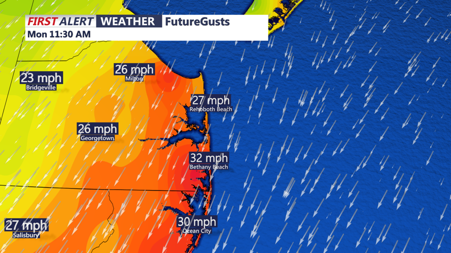
Coastal communities, including Lewes, Rehoboth Beach, Dewey Beach, Bethany Beach and Fenwick Island, will experience the strongest winds as the pressure difference increases between high pressure inland and a strengthening offshore storm.
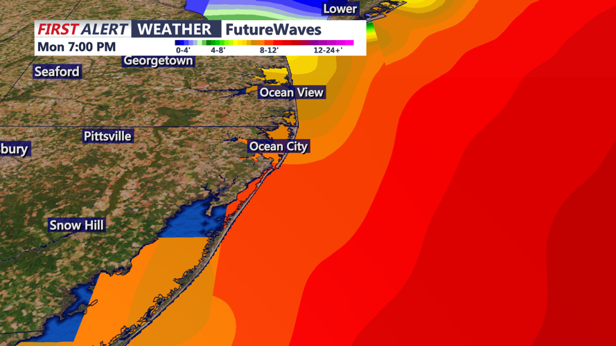
Northeast winds will increase throughout Monday, with gusts potentially reaching 25 to 30 mph along the coast. Stronger gusts are expected over the Atlantic waters, where a Gale Warning takes effect at 6 a.m. Monday and continues through early Wednesday morning.
Marine gusts could reach 40 to 45 mph, producing increasingly rough seas and dangerous conditions for smaller vessels. A Small Craft Advisory will also take effect Monday afternoon across Delaware Bay.
By Monday evening, the developing nor’easter will continue influencing weather conditions along the Delaware coastline. Gusty northeast winds, increasing cloud cover and building surf will remain the primary concerns, while most inland communities should experience relatively limited impacts.
Looking beyond Monday, considerable uncertainty remains regarding the storm's exact track and how long it will remain offshore. However, confidence is increasing that coastal communities could experience several days of persistent northeast winds, rough surf and periods of showers through the middle of the week.
The prolonged onshore flow could also increase the potential for minor coastal flooding, particularly in low-lying areas along the Atlantic beaches, Delaware Bay and surrounding tidal waterways. Residents near Indian River Inlet, Lewes and the back bays should monitor changing tidal conditions and future advisories.
Although widespread inland flooding and significant rainfall are not currently anticipated, the storm's slow movement could prolong coastal impacts through Wednesday and possibly beyond.
Residents, beachgoers and mariners are encouraged to monitor updates from the National Weather Service as forecasters continue refining the storm's track, intensity and potential coastal impacts.
