


DELMARVA - As we move into the weekend, Sussex County is set to experience a dynamic weather pattern. A high-pressure system will move offshore tonight, making way for a strong cold front expected to cross the area later on Saturday. This will be followed by another high-pressure system building in later Sunday into Monday, before it moves offshore again on Tuesday. Additionally, a strong area of low pressure is projected to track across the eastern Great Lakes on Wednesday, moving into the Canadian Maritimes by Thursday, with an associated cold front expected to cross our region later Wednesday or early Thursday.
Saturday:
Morning: The day will start with increasing cloud cover and a noticeable uptick in wind speeds. Morning temperatures are expected to begin around 41°F (5°C) and rise steadily.
Afternoon: Temperatures are anticipated to peak near 66°F (19°C). Winds will intensify, contributing to an elevated fire risk due to gusty winds, low humidity, and dry brush. It's advisable to avoid open flames and ensure any outdoor activities are conducted with caution.
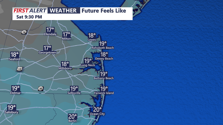
Evening: As evening approaches, temperatures will drop sharply, with lows plummeting to around 26°F (-4°C). The sky will clear up, but the combination of falling temperatures and persistent winds will make it feel considerably colder.
Sunday:
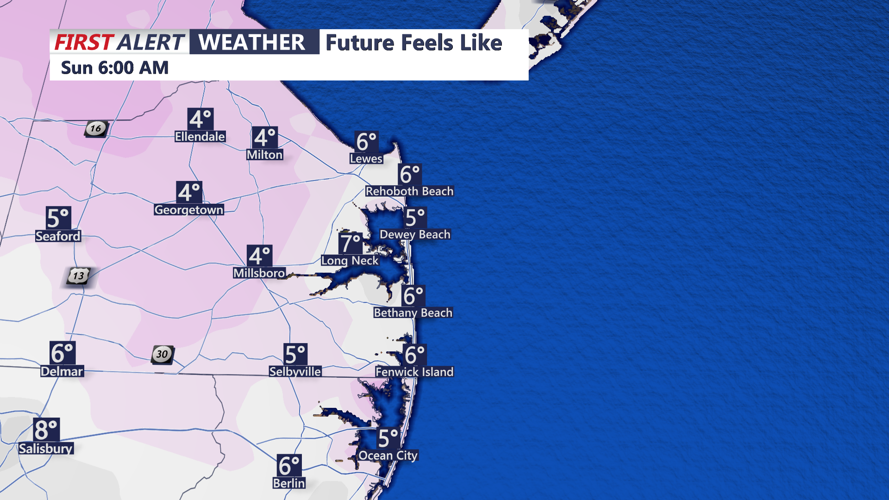
Morning: Residents will wake up to a brisk morning, with temperatures starting around 19°F (-7°C). Breezy conditions will persist, and while the sun will make occasional appearances, the day will remain cold.
Afternoon: Highs are expected to reach only around 40°F (4°C). The combination of cold temperatures and lingering winds will make it feel quite chilly, so dressing warmly is recommended for any outdoor plans.
Evening: Temperatures will drop again in the evening, with lows around 19°F (-7°C). Skies will be partly cloudy, and winds will begin to diminish, leading to calmer conditions overnight.
Monday:
Morning: A cold start to the day with temperatures in the low 20s. However, high pressure will bring plenty of sunshine, offering a slight reprieve from the weekend's colder conditions.
Afternoon: Temperatures are expected to climb into the low 40s, still below normal for this time of year but slightly warmer than Sunday.
Evening: Clear skies will lead to another cold night, with temperatures dropping back into the low 20s.
Throughout the weekend, it's crucial to stay updated with local weather advisories, especially concerning the high fire threat on Saturday. Taking necessary precautions can help ensure safety during these varying weather conditions. Stay tuned to Coast-TV for updates!!!