


DELMARVA -- A stalled front nearby will move north as a warm front this afternoon and evening, increasing the heat and humidity through the end of the week across Delmarva.
An upper level ridge building in from the southwest will gradually reduce the coverage of storms through the end of the week.
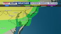
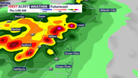
Expect a mix of sun and clouds this afternoon, with a chance of isolated showers and storms this evening. Some heavy rain could accompany some storms. Local flooding in some spots. Highs in the low to mid 90s, with feels like temperatures near 100.
Overnight, we still have a chance of showers and storms that could create local flooding. Showers ending late with lows in the upper 70s to near 80.
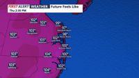
The focus shifts to intensifying heat and humidity. Warm air advection from the southwest will send heat index values into the lower triple digits by Thursday, creating potentially dangerous conditions for outdoor activities. The oppressive heat lingers into Friday, with highs in the low to mid 90s, and triple digit heat indices, with heat indices as high as 107 Thursday.
By Friday we remain hot and humid with highs in near 90 and the heat index 100-104, can't rule out an isolated t-storm.
The weekend right now looks not as hot, but staying humid with highs in the upper 80s. Saturday looks primarily rain free, Sunday as a cold front approaches afternoon and evening isolated t-storms are possible, highs in the mid to upper 80s.


