


DELMARVA - The stretch from early Wednesday through early Friday will feature a transition to wet, humid weather across Sussex County, with rounds of showers, possible thunderstorms, and fluctuation in precipitation intensity.
Wednesday:
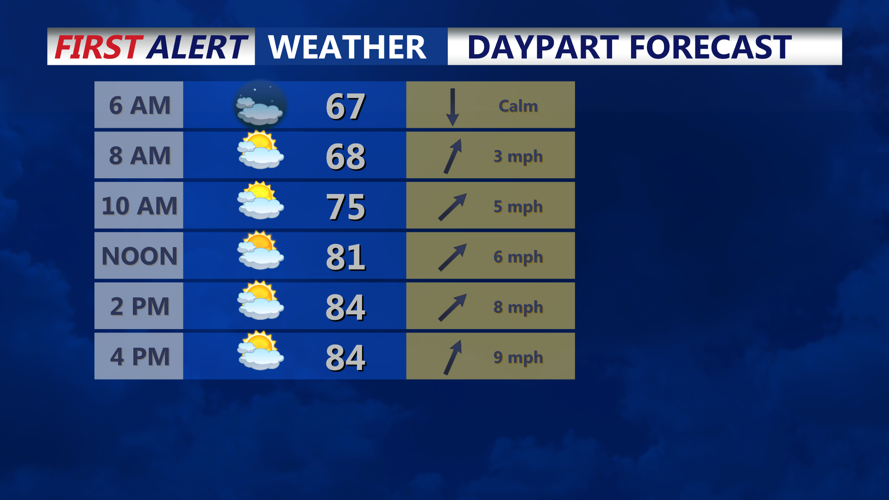
Morning and early afternoon will be warm and partly sunny, with highs in the mid-80s. Humidity levels will climb, setting the stage for instability later in the day. By late afternoon or evening, scattered showers and thunderstorms are possible, particularly as a slow-moving cold front approaches. Nighttime brings more cloud cover with lingering chances of showers and thunderstorms. Lows will remain mild in the upper 60s.
Thursday into Thursday Night:
This is when the weather turns more active. The cold front will move through the region, and there is a high likelihood (50-70%) of showers, with thunderstorms possible especially in the afternoon and evening hours. Rainfall may be heavy at times, with some localized higher amounts, particularly during thunderstorm episodes. Expect steady or frequent rainfall into Thursday night. Highs during the day will be in the lower 80s. Overnight lows mainly in the upper 60s, though areas under heavy rain may see somewhat cooler pockets.
Early Friday:
By early Friday, the front is expected to have largely passed, though showers will linger in some spots, especially in the morning. Skies remain mostly cloudy, humidity stays elevated, and temperatures will still be above seasonal norms with highs near 80°F. The chance of thunderstorms drops but isn’t zero early in the day. Overnight into Friday night, conditions will slowly improve, though cloud cover and intermittent showers may persist in spots.
Impacts & Tips:
Flooding potential in localized areas under heavier thunderstorms, especially Thursday afternoon through the night.
Outdoor plans late Thursday may be disrupted; have backup arrangements.
With muggy conditions and warm overnight lows, humidity will make it feel warmer than official temperatures.
Travel during late Thursday/early Friday may be slowed by wet roads, reduced visibility in heavier rain.