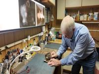
...COASTAL FLOOD ADVISORY IN EFFECT FROM 7 AM TO 1 PM EST
MONDAY...
* WHAT...Up to one half foot of inundation above ground level
expected in low-lying areas near shorelines and tidal
waterways.
* WHERE...In Delaware, Inland Sussex and Delaware Beaches. In
New Jersey, Cape May and Atlantic Coastal Cape May.
* WHEN...From 7 AM to 1 PM EST Monday.
* IMPACTS...At this level, flooding begins on the most
vulnerable roads in coastal and bayside communities, and along
inland tidal waterways. Some partial or full road closures are
possible.
* ADDITIONAL DETAILS...Ice from the back bays could get pushed
onshore during high tide, and flood waters could freeze on
roadways, further complicating impacts.
PRECAUTIONARY/PREPAREDNESS ACTIONS...
A Coastal Flood Advisory means that minor tidal flooding is
expected. Minor tidal flooding often results in some road
closures. Usually, the most vulnerable roadways will flood.
Do not leave your vehicle at a location that is prone to tidal
flooding. Do not drive your vehicle through flood waters. The
water may be deeper than you think it is. You will be putting
yourself in danger and your vehicle may be damaged, leading to
costly repairs.
Visit the National Water Prediction Service at
https://water.noaa.gov/wfo/phi for additional water level and
flood impact information for your local tide gauge.
&&
Time of high total tides are approximate to the nearest hour.
Delaware Bay at Lewes
MLLW Categories - Minor 6.0 ft, Moderate 7.0 ft, Major 8.0 ft
MHHW Categories - Minor 1.3 ft, Moderate 2.3 ft, Major 3.3 ft
Total Total Departure
Day/Time Tide Tide from Norm Flood
ft MLLW ft MHHW ft Impact
-------- --------- --------- --------- --------
01/08 PM 5.1 0.5 1.5 None
02/09 AM 6.3 1.7 1.5 Minor
02/09 PM 5.1 0.5 1.3 None
03/09 AM 5.7 1.0 1.1 None
03/10 PM 4.7 0.0 0.8 None
04/10 AM 5.1 0.5 0.7 None
Great Egg Harbor Bay at Ocean City
MLLW Categories - Minor 5.3 ft, Moderate 6.3 ft, Major 7.3 ft
MHHW Categories - Minor 1.3 ft, Moderate 2.3 ft, Major 3.3 ft
Total Total Departure
Day/Time Tide Tide from Norm Flood
ft MLLW ft MHHW ft Impact
-------- --------- --------- --------- --------
01/08 PM 4.8 0.8 1.5 None
02/08 AM 5.6 1.6 1.2 Minor
02/09 PM 4.3 0.3 0.9 None
03/09 AM 4.8 0.8 0.6 None
03/09 PM 3.7 -0.3 0.3 None
04/09 AM 4.2 0.2 0.3 None
Cape May Harbor at Cape May
MLLW Categories - Minor 6.2 ft, Moderate 7.2 ft, Major 8.2 ft
MHHW Categories - Minor 1.1 ft, Moderate 2.1 ft, Major 3.1 ft
Total Total Departure
Day/Time Tide Tide from Norm Flood
ft MLLW ft MHHW ft Impact
-------- --------- --------- --------- --------
01/08 PM 6.0 0.9 1.9 None
02/08 AM 6.6 1.5 1.3 Minor
02/09 PM 5.5 0.4 1.3 None
03/09 AM 6.2 1.1 1.1 Minor
03/09 PM 5.0 -0.1 0.7 None
04/10 AM 5.5 0.4 0.6 None
&&