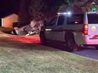
...FLASH FLOOD WARNING REMAINS IN EFFECT UNTIL 545 PM EDT THIS
AFTERNOON FOR SOUTHEASTERN SUSSEX COUNTY...
At 200 PM EDT, Doppler radar indicated thunderstorms producing heavy
rain across the warned area. Between 2 and 3 inches of rain have
fallen. The expected rainfall rate is 1 to 2 inches in 1 hour.
Additional rainfall amounts of 1.5 to 3 inches are possible in the
warned area. Flash flooding is ongoing or expected to begin shortly.
HAZARD...Life threatening flash flooding caused by thunderstorms.
SOURCE...Radar.
IMPACT...Life threatening flash flooding of creeks and streams,
urban areas, highways, streets, and underpasses.
Some locations that may experience flash flooding include...
Millsboro, Selbyville, Dagsboro, Millville, Henlopen Acres, Long
Neck, Ocean View, Frankford, South Bethany and Dewey Beach.
PRECAUTIONARY/PREPAREDNESS ACTIONS...
Turn around...don't drown when encountering flooded roads. Most
flood deaths occur in vehicles.
Be aware of your surroundings and do not drive on flooded roads.
&&
FLASH FLOOD...RADAR INDICATED;
FLASH FLOOD DAMAGE THREAT...CONSIDERABLE;
EXPECTED RAINFALL RATE...1-2 INCHES IN 1 HOUR