




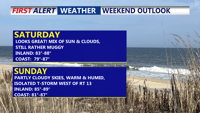
A persistent warm and muggy pattern will continue over Delmarva through early next week, bringing periods of low clouds and patchy fog overnight, with daytime highs in the 80s. While the weekend should remain mostly dry aside from isolated inland storms, a cold front approaching Monday will trigger more widespread showers and thunderstorms. Temperatures will stay above normal into midweek, with heat indices nearing 100 degrees in some locations.
From
To

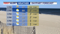
A stalled front across Delmarva Sunday afternoon will keep heat and isolated storms in the forecast to start the week. By Tuesday, a stronger cold front brings the potential for severe thunderstorms. After midweek, high pressure settles in, leading to more comfortable conditions and pleasant weather just in time for the Fourth of July holiday weekend.