site-logo
Facebook Instagram Threads X LinkedIn YouTube LinkedIn
  • Sign Up
  • Log In
  • Dashboard
  • Logout
    • My Account
    • Dashboard
    • Profile
    • Saved items
    • Logout
Home
  • About Us
  • Contact Us
  • Programming
  • Our Team
  • Submit a Tip
  • Newsletters
  • Apps
Sussex County Growth
CoastTV Poll
News
  • Local News
  • Regional News
  • National News
  • International News
  • Feel Good
  • Police and Fire
  • Education
  • Politics
  • Business
  • Area Development
  • Environment
  • Health
  • Roadwork
  • Things to Do
  • Latest Newscasts
  • Featured Videos
  • Immigration
Weather
  • Latest Forecast
  • Weather Cameras
  • Closings
  • Phone
  • Weather101
Traffic
Features
  • Olympics
  • Cool Things
  • Coastal Connections
  • The Ties That Bind Us
  • Week in Review
  • Seaside Guides
  • Pet of the Day
  • Petey the Peacock
  • Salutes
  • Soaring Over the Shore
  • Umbrella Giveaway
  • Photo Booth
  • Lewes Fire Controversy
Delmarva Sports Network
CoastLife
Radio
  • WDEL
  • Coast Country 103.9 & 106.3
  • 93.5 The Beach
  • BIG 107.7
  • 102.5 WBOC
  • 107.1 The Duck
  • 100.9% Classic Country
  • 93.7 WSTW
  • WXCY 103.7 & 96.9
  • WCEI 96.7
  • 94.3 WINX
  • Watch Live
  • Apps
  • Contact Us
  • My Account
  • Sign Up
  • Log In
  • Dashboard
  • Logout
    • My Account
    • Dashboard
    • Profile
    • Saved items
    • Logout
Facebook Instagram Threads X LinkedIn YouTube LinkedIn
  • 14° Clear
    • Milton, DE (19968)

      Today

      A clear sky. Low around 10F. Winds NW at 10 to 20 mph..

      Tonight

      A clear sky. Low around 10F. Winds NW at 10 to 20 mph.

      Updated: February 7, 2026 @ 9:49 pm

    • Full Forecast
site-logo
Saturday, February 7, 2026
Watch Live

Newscast Schedule

View Programming Schedule
site-logo
  • 14°
  • Home
  • News
    • Local News
    • Regional News
    • National News
    • International News
    • Feel Good
    • Police and Fire
    • Education
    • Politics
    • Business
    • Area Development
    • Roadwork
    • Environment
    • Health
    • Things to Do
    • Latest Newscasts
    • Video
    • Immigration
  • Weather
    • Weather Cameras
    • Umbrellas
    • Closings
    • Weather Phone
    • Weather101
  • Traffic
  • Delmarva Sports Network
  • CoastLife
  • Features
    • Cool Things to Do
    • Coastal Connections
    • The Ties That Bind Us
    • Week in Review
    • Seaside Guides
    • Pet of the Day
    • Petey the Peacock
    • Salutes
    • Umbrella Giveaway
    • Photo Booth
    • Soaring Over the Shore
    • Lewes Fire Controversy
    • Olympics
  • Sussex County Growth
  • Poll
  • About Us
    • About CoastTV
    • Bios
    • Contact Us
    • Newsletters
    • Apps
    • Channel Finder
    • Careers
    • Internships
  • Submit a tip
Broadcast Schedule

On air schedule

Weather Alert

Weather Alert

...GALE WARNING IN EFFECT UNTIL 10 AM EST SUNDAY...
...HEAVY FREEZING SPRAY WARNING REMAINS IN EFFECT UNTIL 10 AM EST
SUNDAY...
...STORM WARNING IS CANCELLED...

* WHAT...For the Gale Warning, northwest winds 30 to 40 kt with
gusts up to 45 kt and extremely rough waters. For the Heavy
Freezing Spray Warning, heavy freezing spray at a rate of 2 cm
per hour or greater may rapidly accumulate on vessels.

* WHERE...Delaware Bay waters north of East Point NJ to
Slaughter Beach DE and Delaware Bay waters south of East Point
NJ to Slaughter Beach DE.

* WHEN...Until 10 AM EST Sunday.

* IMPACTS...Operating a vessel in heavy freezing spray is
hazardous. Freezing spray may render mechanical and electronic
components inoperative. Rapid ice accretion on decks and
superstructures may result in a catastrophic loss of
stability. Strong winds will cause hazardous seas which could
capsize or damage vessels and reduce visibility.


PRECAUTIONARY/PREPAREDNESS ACTIONS...

Mariners should prepare for dangerous accumulation of ice on
their vessel. If possible, remain in port, avoid the warning area
or conduct mitigation.

Mariners should alter plans to avoid these hazardous conditions.
Remain in port, seek safe harbor, alter course, and/or secure the
vessel for hazardous conditions.

&&

Weather Alert

...WIND ADVISORY IN EFFECT UNTIL MIDNIGHT EST TONIGHT...
...EXTREME COLD WARNING REMAINS IN EFFECT UNTIL NOON EST SUNDAY...
...HIGH WIND WARNING IS CANCELLED...

* WHAT...For the Wind Advisory, northwest winds 15 to 25 mph with
gusts up to 50 mph. For the Extreme Cold Warning, dangerously cold
wind chills as low as 12 below.

* WHERE...Kent, New Castle, Delaware Beaches, and Inland Sussex
Counties.

* WHEN...For the Wind Advisory, until midnight EST tonight. For the
Extreme Cold Warning, until noon EST Sunday.

* IMPACTS...Gusty winds will blow around unsecured objects. Tree
limbs could be blown down and a few power outages may result. The
cold wind chills as low as 10 below zero could result in
hypothermia if precautions are not taken.

PRECAUTIONARY/PREPAREDNESS ACTIONS...

Remain in the lower levels of your home during the windstorm, and
avoid windows. Watch for falling debris and tree limbs. Use caution
if you must drive.

Secure outdoor objects.

Dress in layers including a hat, face mask, and gloves if you must
go outside.

If you do not have heat in your home or lack shelter, you can call
211 for assistance locating appropriate shelter from the cold.

&&

Closings

Click here to view closings and delays

Advanced Search Close Search
From
To
Close Search
+4
Beach towns restrict ocean access as Erin’s rough seas lash Delmarva
Weather

Beach towns restrict ocean access as Erin’s rough seas lash Delmarva

  • Chief Meteorologist Paul Williams
  • Updated Aug 18, 2025

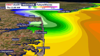
From Slaughter Beach to Ocean City, residents are bracing for dangerous surf, coastal flooding, and gusty winds as Hurricane Erin churns offshore.


site-logo
Facebook Instagram Threads X BlueSky YouTube LinkedIn

    Sections

    • Home
    • News
    • Weather
    • CoastLife
    • Delmarva Sports Network
    • Telemundo Delmarva

    Services

    • Contact Us
    • Submit a tip
    • Search
    • CoastTV Poll
    • Newsletter
    • Careers
    • Internships

    Browser Compatibility

    Your browser is out of date and potentially vulnerable to security risks.
    We recommend switching to one of the following browsers:

    Microsoft Edge Google Chrome Firefox
    © Copyright 2026 CoastTV One The Sq, Milton, DE  | Terms of Use  | Privacy Policy
    Powered by BLOX Content Management System from BLOX Digital.