site-logo
Facebook Instagram Threads X LinkedIn YouTube LinkedIn
  • Sign Up
  • Log In
  • Dashboard
  • Logout
    • My Account
    • Dashboard
    • Profile
    • Saved items
    • Logout
Home
  • About Us
  • Contact Us
  • Programming
  • Advertising
  • Our Team
  • Submit a Tip
  • Newsletters
  • Apps
CoastTV Poll
News
  • Local News
  • Regional News
  • National News
  • International News
  • Feel Good
  • Police and Fire
  • Education
  • Politics
  • Business
  • Area Development
  • Environment
  • Health
  • Roadwork
  • Things to Do
  • Latest Newscasts
  • Featured Videos
  • Immigration
Weather
  • Latest Forecast
  • Weather Cameras
  • Closings
  • Phone
  • Beyond the Forecast
Continuing Coverage
  • Lewes City Hall Investigations
Traffic
Features
  • Cool Things
  • Feel Good Friday Quiz
  • Coastal Connections
  • The Ties That Bind Us
  • Week in Review
  • Seaside Guides
  • Pet of the Day
  • Petey the Peacock
  • Salutes
  • Soaring Over the Shore
  • Umbrella Giveaway
  • Photo Booth
  • America 250
Delmarva Sports Network
CoastLife
Radio
  • WDEL
  • Coast Country 103.9 & 106.3
  • 93.5 The Beach
  • BIG 107.7
  • 102.5 WBOC
  • 107.1 The Duck
  • 100.9% Classic Country
  • 93.7 WSTW
  • WXCY 103.7 & 96.9
  • WCEI 96.7
  • 94.3 WINX
  • Watch Live
  • Apps
  • Contact Us
  • My Account
  • Sign Up
  • Log In
  • Dashboard
  • Logout
    • My Account
    • Dashboard
    • Profile
    • Saved items
    • Logout
Facebook Instagram Threads X LinkedIn YouTube LinkedIn
  • 76°
    • Milton, DE (19968)

      Today

      Thunderstorms, some strong during the evening will give way to mostly cloudy skies after midnight. Damaging winds, large hail and possibly a tornado with some storms. Low 68F. Winds WSW at 5 to 10 mph. Chance of rain 100%..

      Tonight

      Thunderstorms, some strong during the evening will give way to mostly cloudy skies after midnight. Damaging winds, large hail and possibly a tornado with some storms. Low 68F. Winds WSW at 5 to 10 mph. Chance of rain 100%.

      Updated: July 28, 2026 @ 8:11 pm

    • Full Forecast
site-logo
Tuesday, July 28, 2026
Watch Live

Newscast Schedule

View Programming Schedule
site-logo
  • 76°
  • Home
  • News
    • Local News
    • Regional News
    • National News
    • International News
    • Feel Good
    • Police and Fire
    • Education
    • Politics
    • Business
    • Area Development
    • Roadwork
    • Environment
    • Health
    • Things to Do
    • Latest Newscasts
    • Video
    • Immigration
  • Weather
    • Weather Cameras
    • Umbrellas
    • Closings
    • Weather Phone
    • Beyond the Forecast
  • Continuing Coverage
    • Lewes City Hall Investigations
  • Traffic
  • Delmarva Sports Network
  • CoastLife
  • Features
    • America 250
    • Feel Good Friday Quiz
    • Cool Things to Do
    • Coastal Connections
    • The Ties That Bind Us
    • Week in Review
    • Seaside Guides
    • Pet of the Day
    • Petey the Peacock
    • Salutes
    • Umbrella Giveaway
    • Photo Booth
    • Soaring Over the Shore
  • Poll
  • About Us
    • About CoastTV
    • Bios
    • Newsletters
    • Apps
    • Channel Finder
    • Careers
    • Internships
    • Advertising
    • Contact Us
  • Submit a tip
Broadcast Schedule

On air schedule

Weather Alert

Weather Alert

...A TORNADO WARNING REMAINS IN EFFECT UNTIL 845 PM EDT FOR EAST
CENTRAL SUSSEX COUNTY...

At 815 PM EDT, severe thunderstorms capable of producing tornadoes
were located along a line extending from near Henlopen Acres to near
Millville, moving east at 35 mph.

HAZARD...Tornado.

SOURCE...Radar indicated rotation.

IMPACT...Flying debris will be dangerous to those caught without
shelter. Mobile homes will be damaged or destroyed. Damage
to roofs, windows, and vehicles will occur.  Tree damage is
likely.

Locations impacted include...
Henlopen Acres, Long Neck, and Dewey Beach.

PRECAUTIONARY/PREPAREDNESS ACTIONS...

TAKE COVER NOW! Move to a basement or an interior room on the lowest
floor of a sturdy building. Avoid windows. If you are outdoors, in a
mobile home, or in a vehicle, move to the closest substantial shelter
and protect yourself from flying debris.

Torrential rainfall is occurring with these storms, and may lead to
flash flooding. Do not drive your vehicle through flooded roadways.

&&


TORNADO...RADAR INDICATED;
MAX HAIL SIZE...<.75 IN

Weather Alert

...A SEVERE THUNDERSTORM WARNING REMAINS IN EFFECT UNTIL 830 PM EDT
FOR SUSSEX COUNTY...

At 811 PM EDT, severe thunderstorms were located along a line
extending from near Lewes to Dagsboro to Delmar, moving east at 40
mph.

HAZARD...60 mph wind gusts.

SOURCE...Radar indicated.

IMPACT...Damage to roofs, siding, trees, and power lines is
possible.

Locations impacted include...
Georgetown, Seaford, Millsboro, Laurel, Lewes, Milton, Selbyville,
Delmar, Dagsboro, Millville, Ellendale, Henlopen Acres, Gumboro, Cape
Henlopen State Park, Sycamore, Long Neck, Ocean View, Blades,
Frankford, and South Bethany.

PRECAUTIONARY/PREPAREDNESS ACTIONS...

A Tornado Watch remains in effect until 1000 PM EDT for southern
Delaware...and eastern Maryland.

Remain alert for a possible tornado! Tornadoes can develop quickly
from severe thunderstorms. If you spot a tornado go at once into the
basement or small central room in a sturdy structure.

For your protection move to an interior room on the lowest floor of a
building.

Frequent cloud to ground lightning is occurring with these storms.
Move indoors immediately. Lightning is one of nature's leading
killers. Remember, if you can hear thunder, you are close enough to
be struck by lightning.

Torrential rainfall is occurring with these storms, and may lead to
flash flooding. Do not drive your vehicle through flooded roadways.

&&


TORNADO...POSSIBLE;
HAIL THREAT...RADAR INDICATED;
MAX HAIL SIZE...<.75 IN;
WIND THREAT...RADAR INDICATED;
MAX WIND GUST...60 MPH

Weather Alert

TORNADO WATCH 529 REMAINS VALID UNTIL 10 PM EDT THIS EVENING FOR
THE FOLLOWING AREAS

IN DELAWARE THIS WATCH INCLUDES 3 COUNTIES

IN CENTRAL DELAWARE

KENT

IN NORTHERN DELAWARE

NEW CASTLE

IN SOUTHERN DELAWARE

SUSSEX

IN MARYLAND THIS WATCH INCLUDES 4 COUNTIES

IN NORTHEAST MARYLAND

CAROLINE              KENT                  QUEEN ANNE'S
TALBOT

IN NEW JERSEY THIS WATCH INCLUDES 8 COUNTIES

IN SOUTHERN NEW JERSEY

ATLANTIC              BURLINGTON            CAMDEN
CAPE MAY              CUMBERLAND            GLOUCESTER
OCEAN                 SALEM

IN PENNSYLVANIA THIS WATCH INCLUDES 5 COUNTIES

IN SOUTHEAST PENNSYLVANIA

BUCKS                 CHESTER               DELAWARE
MONTGOMERY            PHILADELPHIA

THIS INCLUDES THE CITIES OF ATLANTIC CITY, CAMDEN, CENTREVILLE,
CHERRY HILL, CHESTERTOWN, DENTON, DEPTFORD, DOVER, DOYLESTOWN,
EASTON, GEORGETOWN, GLASSBORO, HAMMONTON, MEDIA, MILLVILLE,
MOORESTOWN, MOUNT HOLLY, NORRISTOWN, OCEAN CITY, PENNSVILLE,
PHILADELPHIA, TOMS RIVER, WEST CHESTER, AND WILMINGTON.

Weather Alert

TORNADO WATCH 529 REMAINS VALID UNTIL 10 PM EDT THIS EVENING FOR
THE FOLLOWING AREAS

THIS WATCH INCLUDES THE FOLLOWING ADJACENT COASTAL WATERS

DELAWARE BAY WATERS NORTH OF EAST POINT NJ TO SLAUGHTER BEACH DE
DELAWARE BAY WATERS SOUTH OF EAST POINT NJ TO SLAUGHTER BEACH DE
COASTAL WATERS FROM GREAT EGG INLET TO CAPE MAY NJ OUT 20 NM
COASTAL WATERS FROM CAPE MAY NJ TO CAPE HENLOPEN DE OUT 20 NM
COASTAL WATERS FROM CAPE HENLOPEN TO FENWICK ISLAND DE OUT 20 NM

Weather Alert

The National Weather Service in Mount Holly NJ has issued a

* Special Marine Warning for...
Delaware Bay...
Coastal and outer waters from Great Egg Inlet NJ to Fenwick Island
DE...

* Until 930 PM EDT.

* At 723 PM EDT, severe thunderstorms capable of producing
waterspouts were located along a line extending from 7 nm west of
Bowers Beach to 12 nm west of Slaughter Beach to 18 nm east of
Miles River, moving east at 35 knots.

HAZARD...Waterspouts, wind gusts to 40 knots, and small hail.

SOURCE...Radar.

IMPACT...Waterspouts can easily overturn boats and create locally
hazardous seas. Small craft could be damaged in briefly
higher winds and suddenly higher waves.

* Locations impacted include...
Five Fathoms Buoy, Buoy 2fb, Brown Shoal Light, Fenwick Island,
Buoy 4fb, Buoy 3fb, Slaughter Beach, Cape Henlopen, East Point,
Deepwater Reef, Miah Maull Light, Brandywine Shoal Light, Ocean
City Reef, Indian River Inlet Bridge, Overfalls Shoal, The Lump,
28-
Mile Wreck, Bethany Beach, Cross Ledge Light, and Fourteen Foot
Bank Light.

PRECAUTIONARY/PREPAREDNESS ACTIONS...

A Tornado Watch remains in effect until 1000 PM EDT for central and
southern Delaware...southern New Jersey...and the adjacent coastal
waters.

Move to safe harbor until hazardous weather passes.

&&


WATERSPOUT...POSSIBLE;
HAIL...<.75IN;
WIND...40KTS

Advanced Search Close Search
From
To
Close Search
+4
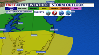
Isolated Severe Storms Possible Before Pleasant Stretch
Weather

Isolated Severe Storms Possible Before Pleasant Stretch

  • Meteorologist Chris Mastrobuono
  • Jul 22, 2026

A few strong storms and localized flooding remain possible today before cooler, drier weather settles across Delmarva.

site-logo
Facebook Instagram Threads X BlueSky YouTube LinkedIn

    Sections

    • Home
    • News
    • Weather
    • CoastLife
    • Delmarva Sports Network
    • Telemundo Delmarva

    Services

    • Contact Us
    • Advertising
    • Submit a tip
    • Search
    • Newsletter
    • Apps
    • Careers
    • Internships

    Browser Compatibility

    Your browser is out of date and potentially vulnerable to security risks.
    We recommend switching to one of the following browsers:

    Microsoft Edge Google Chrome Firefox
    © Copyright 2026 CoastTV One The Sq, Milton, DE  | Terms of Use  | Privacy Policy
    Powered by BLOX Content Management System from BLOX Digital.