Storyline

Hot weather continues for one more day, slightly cooler but still above average into Friday.

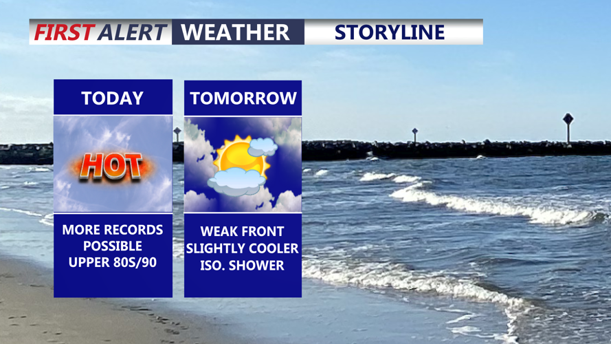
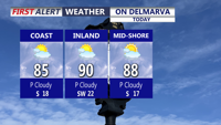
DELMARVA -- Today brings another very warm day across Delmarva, extending this stretch of unusual April heat into a third straight day. High pressure parked over the Atlantic and a warm front positioned well north of the Mid-Atlantic will keep the region locked in summerlike warmth. Temperatures are expected to climb into the upper 80s to around 90 degrees under partly cloudy skies, running about 15 to 30 degrees above normal for this time of year. In Georgetown, the record high for today is 89 degrees, set in 2002, and that mark could be challenged.

On Delmarva

Another day of record temperatures are likely as the unseasonably warm air continues.

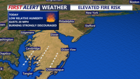
Along with the heat, dry conditions will raise concerns for fire spread across Delmarva. Relative humidity values are expected to fall into the 25 to 35 percent range, while southwest winds increase to around 10 to 15 mph with gusts up to 20 mph this afternoon. With little recent rainfall and ongoing drought or abnormally dry conditions in place, any fire that starts could spread more easily.

Elevated Fire Risk

With the overall dry conditions, low relative humidity and southwest winds there is a fire concern this afternoon.

Tonight into Friday, a weak front will slip through the region, bringing slightly cooler air but not a major change. Highs Friday will still reach the low 80s under partly cloudy skies, and while a stray sprinkle cannot be ruled out, most areas will stay dry.

Rain Chances Next 7 Days

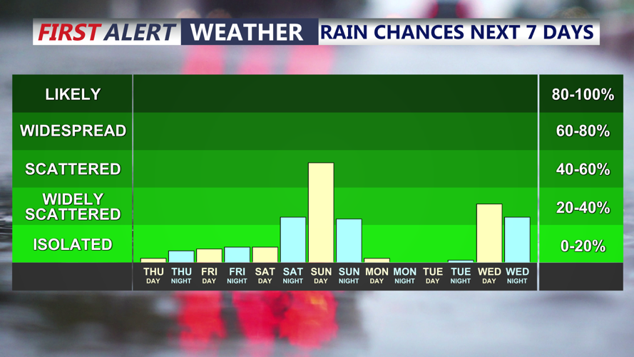
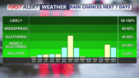
Some small rain chances over the next 7 days, not a whole lot of rain expected.

By Saturday, a backdoor cold front may begin working into at least part of the region. That will likely create a sharp temperature contrast across Delmarva, with coastal areas turning much cooler in the 50s and 60s, while inland and western sections of the peninsula still reach the 70s and 80s.

The bigger weather change arrives late Saturday night into Sunday morning as a strong cold front crosses the area ahead of a deep upper-level trough settling over the East. A weak area of low pressure may develop along the front nearby, helping produce a better chance for showers. While the risk for thunderstorms appears low, this system should bring much-needed rainfall to Delmarva and usher in a much more noticeable cooldown for Sunday and early next week.

Behind the front, gusty winds are expected to develop and continue into Sunday, which should help limit frost formation Sunday night. However, as colder air settles in and winds relax with high pressure building overhead, frost and possibly freeze conditions may develop Monday night into early Tuesday morning.

After the chilly start to next week, temperatures will begin to recover Tuesday afternoon, with a more noticeable warmup expected by Wednesday.


Meteorologist

Chris Mastrobuono is a South Philly native, but has come to join the CoastTV meteorology team. With over three years of experience delivering accurate, passionate and insightful weather analysis, he is eager to report on the coast. Previously, he spent over two years as a morning meteorologist at WEVV CBS/FOX in Evansville, Indiana. 

Recommended for you