


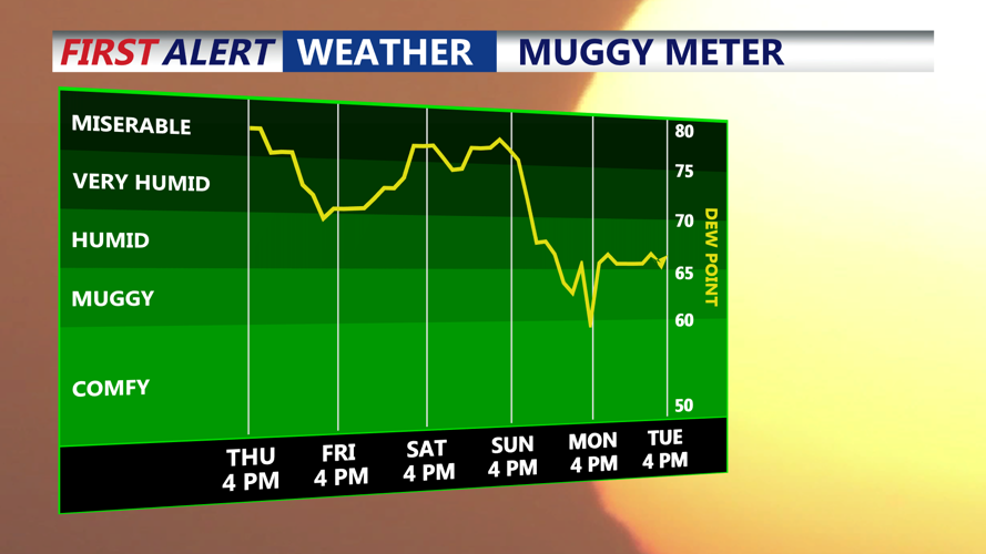


DELMARVA - Friday starts off more comfortable, thanks to the cold front that passed through Thursday night. Humidity will be noticeably lower, with dew points dropping into the 50s and 60s. Most of the region will see partly sunny skies and highs in the low to mid-80s—right around or slightly below normal for mid-July.
However, the front that brought the relief will stall just to our south and east. This could spark some lingering clouds and isolated showers, particularly across the Delmarva Peninsula and coastal South Jersey. Areas farther inland will enjoy a mainly dry and pleasant day.
Friday Night:
As high pressure builds over New England, it will keep most of the region dry overnight. However, an area of low pressure skimming by to the south could continue to bring occasional showers to Delmarva and southeastern areas. Lows will generally range from the mid to upper 60s, with cooler spots in the upper 50s across higher elevations in Pennsylvania.
Saturday Outlook:
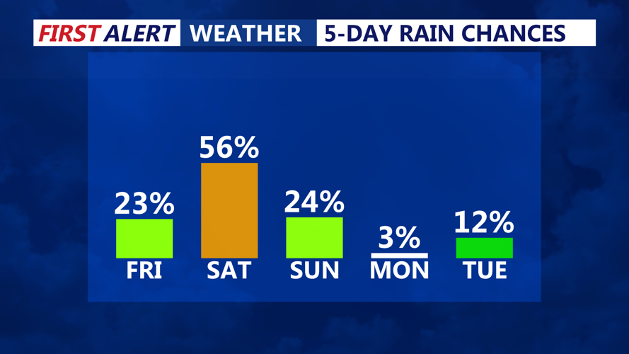
A subtle shift in the upper-level pattern introduces a weak disturbance that will increase shower and thunderstorm chances across the entire region by Saturday afternoon and evening. While instability remains modest and widespread severe weather is not expected, deep atmospheric moisture could result in pockets of heavy rainfall.
The Weather Prediction Center has placed most of the area under a Marginal Risk (Level 1 of 4) for excessive rainfall, particularly from late Saturday afternoon into the overnight hours. Flash flooding is not widespread, but localized downpours may lead to brief flooding in low-lying or poorly drained areas.
Saturday Night:
Scattered showers and a few thunderstorms will linger into the evening and early overnight hours. The air will feel muggy once again as moisture surges ahead of an approaching stronger cold front. Temperatures overnight will hold in the mid-60s to low 70s.
Sunday (Early Morning Preview):
Early Sunday remains unsettled with scattered showers possible during the morning, especially ahead of the next frontal boundary. By Sunday afternoon, a more potent cold front is expected to sweep across the region, bringing another round of scattered storms, with potential for stronger activity due to increased instability and wind shear. This will be closely monitored heading into the weekend.