


Two weeks ago Tropical Storm Isaias tore through Delmarva producing one of the largest tornado outbreaks in Delmarva history. 14 Tornado Warnings were issued in Sussex, Wicomico, Worcester, Dorchester, and Somerset counties. 6 other Tornado Warnings were issued in other counties farther north on Delmarva. Before all was said and done 9 tornadoes wreaked havoc on Delmarva, tearing down trees, downing power lines, and severely damaging homes and businesses.
Out of the 9 tornadoes; 3 were rated EF-2s, 2 were EF-1s, and 4 were EF-0s. The strongest tornado of the day occurred in Mardela Springs, MD at around 5:55am. The Mardela Springs tornado was rated as an EF-2 tornado with winds estimated between 120-125 mph which is the strongest tornado in Wicomico County recorded history. That tornado struck a house on Main St. in Mardela tearing the home off its foundation. That tornado also shredded a camper and downed numerous trees and powerlines. The second tornado of the day was also an EF-2 tornado with winds estimated at 115 mph which struck around 7:13am in Stockton, MD. That tornado in Stockton, MD was the strongest tornado in Worcester County recorded history. Damage from the Stockton, MD tornado ranged from shattered windshields of cars, damage to roofs of homes, flipped campers, and downed trees and powerlines.
The next four tornadoes occurred in the hour timeframe between 7:20 am and 8:20 am. All four tornadoes were rated as EF-0s. The first of these tornadoes struck the Greenhill Country Club in Quantico, MD. Another tornado marched through Berlin and moved towards Showell. A third tornado tore a nearly 10 mile path from Assateague Island, MD to Ocean Pines, MD. The fourth tornado formed in Queenstown in Queen Anne’s County, MD.
Delaware received their tornadoes next. At 8:25 am two tornadoes struck simultaneously in Milford and Sandtown. Both of these tornadoes were rated as EF-1s with winds estimated at 100 mph. The Milford tornado resulted in extensive tree damage in the Haven Lake region as it moved northwest towards Houston. Some of those large trees fell on homes and sheds. Powerlines were also brought down. The Sandtown tornado resulted in damage to a couple homes with one home having its roof completely torn off.
The final tornado of the day was an EF-2 with winds estimated at 115 mph. This tornado tore a 35.5 mile path from Dover, DE all the way to Middletown, DE. This path length shattered the old record for the longest tornado path in Delaware recorded history.
Joe Miketta, the Warning Coordination Meteorologist at the National Weather Service in Mount Holly, New Jersey, had this to say about the new record,”The tornado was not on the ground the whole time. It was discontinuous, it would come down on the ground for a while and then lift back up and then come back down, but it was all part of the same circulation, so we feel justified in calling it the same tornado.”
The tornado first touched down near the Eagle Meadows Apartments in Dover at around 8:55 am. From there the tornado downed trees and powerlines, tore roofs off homes, flipped tractor trailers, and damaged schools and businesses until it lifted at around 9:30 am just north of Middletown, DE. At times that tornado was as wide as 500 yards, which is 5 football fields.
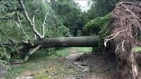
All in all, this tornado outbreak displaced many families, damaged many buildings, and downed hundreds of trees. The clean up is still ongoing in some locations two weeks later. The price tag for this event is in the millions and still rising.