


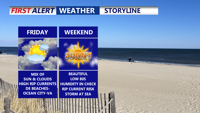
Friday will bring a mix of sun and clouds to the region with highs in the upper 70s to low 80s, but a high risk of rip currents will persist along the Delaware Beaches through Ocean City and Assateague Island. The dangerous surf, driven by onshore flow and a distant storm, is expected to continue into the weekend. High pressure will keep the area mainly dry and mild through Sunday, with lighter winds and slightly warmer temperatures Saturday. Sunday will be sunny and seasonable before heat and humidity build early next week, with widespread 90s and a chance for storms by midweek.
From
To

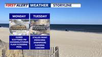
Delmarva will experience warm, humid conditions with a daily risk of showers and storms. Fog and mist are likely to start the day, especially along the coast. A cold front arriving late Monday will trigger scattered thunderstorms and downpours into the evening. This front is expected to stall through midweek, sustaining unsettled weather with periods of heavy rain, though the severe threat remains low. Can't rule out the possibility of flash flooding. By late week, heat and humidity will intensify, pushing heat index values toward 100 degrees before another cold front approaches.

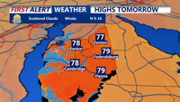
An upper-level low will bring increased shower chances and lower temperatures on Tuesday with a warming trend and mostly dry conditions expected on Wednesday.