


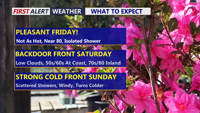
Today stays warm and sunny across Delmarva, but temperatures step down from yesterday’s record highs. Cooler air arrives near the coast Saturday as a backdoor front pushes in, while inland areas stay milder. Minor tidal flooding is expected along the Delaware coast and Delaware Bay Saturday evening into Saturday night, followed by showers, a few thunderstorms, and a sharp cool down late Saturday night into Sunday. Much colder air settles in early next week, with widespread frost or freeze conditions likely Monday night into Tuesday morning.
From
To

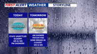
A gloomy, damp day continues across Delmarva with highs in the upper 40s to low 50s inland. Scattered showers and drizzle develop this evening and overnight with patchy fog and lows in the mid to upper 40s. Temperatures trend much warmer midweek into early next week (10–20° above average), though a back-and-forth front late week could create sharp north/south temperature differences and several chances for showers—plus a small thunder risk Thursday night.