...COASTAL FLOOD ADVISORY REMAINS IN EFFECT FROM 8 PM THIS
EVENING TO 2 AM EDT SUNDAY...
* WHAT...Up to one foot of inundation above ground level
expected in low-lying areas near shorelines and tidal
waterways.
* WHERE...In Delaware, Inland Sussex and Delaware Beaches. In
New Jersey, Cape May and Atlantic Coastal Cape May.
* WHEN...From 8 PM this evening to 2 AM EDT Sunday.
* IMPACTS...At this level, flooding begins on the most
vulnerable roads in coastal and bayside communities, and along
inland tidal waterways. Some partial or full road closures are
possible.
PRECAUTIONARY/PREPAREDNESS ACTIONS...
A Coastal Flood Advisory means that minor tidal flooding is
expected. Minor tidal flooding often results in some road
closures. Usually, the most vulnerable roadways will flood.
Do not leave your vehicle at a location that is prone to tidal
flooding. Do not drive your vehicle through flood waters. The
water may be deeper than you think it is. You will be putting
yourself in danger and your vehicle may be damaged, leading to
costly repairs.
Visit the National Water Prediction Service at
https://water.noaa.gov/wfo/phi for additional water level and
flood impact information for your local tide gauge.
&&
Time of high total tides are approximate to the nearest hour.
Delaware Bay at Lewes
MLLW Categories - Minor 6.0 ft, Moderate 7.0 ft, Major 8.0 ft
MHHW Categories - Minor 1.3 ft, Moderate 2.3 ft, Major 3.3 ft
Total Total Departure
Day/Time Tide Tide from Norm Flood
ft MLLW ft MHHW ft Impact
-------- --------- --------- --------- --------
18/10 PM 6.6 2.0 1.3 Minor
19/10 AM 4.9 0.2 1.0 None
19/11 PM 6.2 1.5 0.9 Minor
20/11 AM 4.2 -0.5 0.4 None
21/12 AM 5.8 1.2 0.6 None
21/01 PM 4.5 -0.2 0.8 None
Great Egg Harbor Bay at Ocean City
MLLW Categories - Minor 5.3 ft, Moderate 6.3 ft, Major 7.3 ft
MHHW Categories - Minor 1.3 ft, Moderate 2.3 ft, Major 3.3 ft
Total Total Departure
Day/Time Tide Tide from Norm Flood
ft MLLW ft MHHW ft Impact
-------- --------- --------- --------- --------
18/10 PM 5.7 1.7 0.9 Minor
19/09 AM 4.2 0.2 0.8 None
19/10 PM 5.1 1.1 0.4 None
20/10 AM 3.4 -0.6 0.1 None
20/11 PM 4.7 0.7 0.1 None
21/12 PM 3.6 -0.4 0.2 None
Cape May Harbor at Cape May
MLLW Categories - Minor 6.2 ft, Moderate 7.2 ft, Major 8.2 ft
MHHW Categories - Minor 1.1 ft, Moderate 2.1 ft, Major 3.1 ft
Total Total Departure
Day/Time Tide Tide from Norm Flood
ft MLLW ft MHHW ft Impact
-------- --------- --------- --------- --------
18/10 PM 6.9 1.8 1.0 Minor
19/10 AM 5.2 0.1 0.7 None
19/10 PM 6.4 1.3 0.5 Minor
20/11 AM 4.4 -0.7 0.1 None
20/11 PM 6.0 0.9 0.3 None
21/12 PM 4.6 -0.5 0.6 None
&&
Weather Alert
...DENSE FOG ADVISORY NOW IN EFFECT UNTIL 1 AM EDT SUNDAY...
...SMALL CRAFT ADVISORY REMAINS IN EFFECT FROM 8 AM TO 6 PM EDT
SUNDAY...
* WHAT...For the Dense Fog Advisory, dense fog will reduce
visibility to 1 nm or less. For the Small Craft Advisory,
northwest winds 15 to 25 kt with gusts up to 30 kt and rough
waters expected.
* WHERE...Delaware Bay waters south of East Point NJ to
Slaughter Beach DE.
* WHEN...For the Dense Fog Advisory, until 1 AM EDT Sunday. For
the Small Craft Advisory, from 8 AM to 6 PM EDT Sunday.
* IMPACTS...Conditions will be hazardous to small craft. Low
visibility will make navigation difficult.
* ADDITIONAL DETAILS...There is a small chance for gale
conditions, particularly at the mouth of the Delaware Bay late
Sunday Morning.
PRECAUTIONARY/PREPAREDNESS ACTIONS...
Inexperienced mariners, especially those operating smaller
vessels, should avoid navigating in hazardous conditions.
If you must navigate, proceed with caution. Use proper fog
signals. Make sure all running lights are on. Remember to use
your radar and compass.
&&
Beautiful Friday, turns cooler over the weekend, strong cold front brings a chance of showers Sunday.
Chris Mastrobuono is a South Philly native, but has come to join
the CoastTV meteorology team. With over three years of experience
delivering accurate, passionate and insightful weather analysis, he
is eager to report on the coast. Previously, he spent over two
years as a morning meteorologist at WEVV CBS/FOX in Evansville,
Indiana.
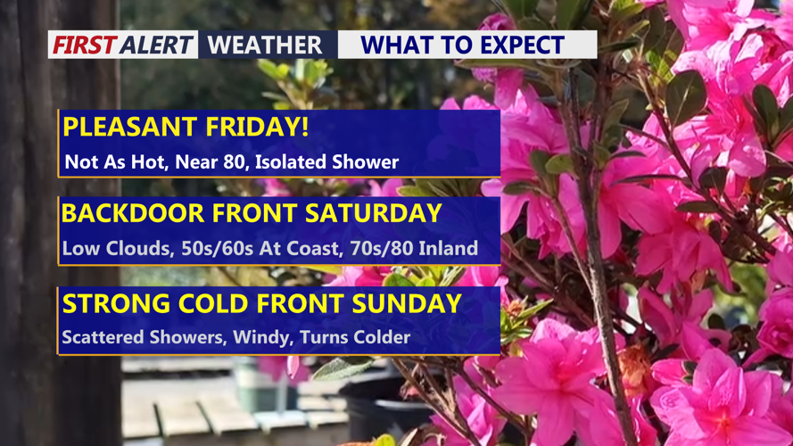
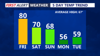
DELMARVA -- W say goodbye to record-breaking heat, but it will still be another very warm day for mid-April. High temperatures will run about 10 degrees lower than yesterday, though they will remain above average under mostly sunny skies. A weak trough moved through this morning, and behind it a northwest flow has developed, helping keep afternoon highs around 80 degrees in many areas. Tonight will be mostly clear and mild, with lows settling into the low to mid 50s.
Mostly sunny skies, no record highs but still well above average.
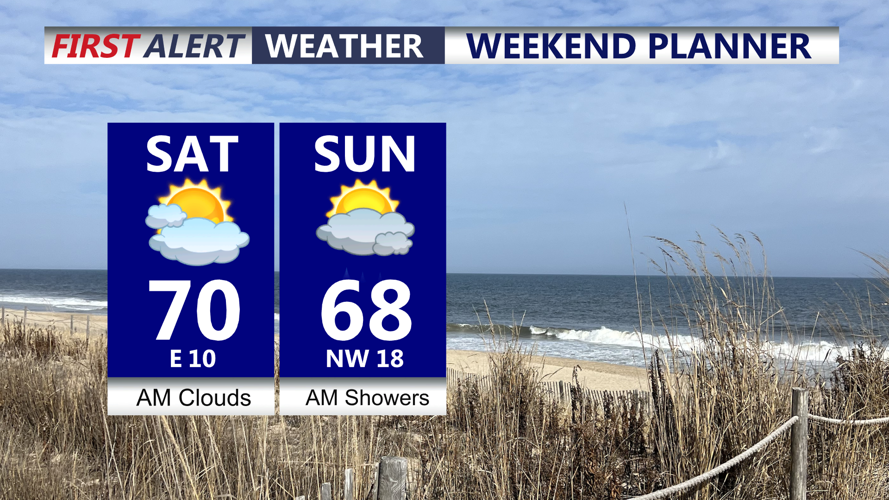
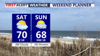
Saturday brings the start of a bigger change in the pattern. A backdoor front will slide southwestward into the region, setting up a northeast to east low-level flow. That will bring noticeably cooler air to communities closest to the coast, while the warmest temperatures hold on farther inland, especially across the Mid-Shore. Highs will reach the 60s at the beaches, while inland spots range through the 70s and could still approach 80 degrees across the Mid-Shore. Even so, temperatures will continue trending downward as Delmarva moves closer to a more significant cool down.
Along with the cooler marine air, tidal flooding concerns will increase. High astronomical tides associated with today’s new moon, combined with persistent onshore flow developing tonight and strengthening Saturday, are expected to produce widespread minor tidal flooding along the Delaware coast and Delaware Bay with the Saturday evening and nighttime high tide. A few isolated spots could see minor flooding around high tide this evening and tonight, but impacts should remain too limited for an advisory. By Saturday evening, southeast winds may push surge values to around one foot above normal, which would place many tidal locations into minor flood stage.
The Eastern Shore along the Chesapeake Bay is not expected to see tidal flooding, but the Delaware beaches and bayfront communities will need to monitor conditions closely through Saturday night.
Late Saturday night into Sunday morning, a strong cold front will sweep across Delmarva as a deep upper trough approaches from the west. That front will bring a period of showers and possibly a few thunderstorms, although the thunder threat remains low at this time. A weak area of low pressure may also try to develop along the boundary nearby. Because the main upper-level energy lags behind the front, some of the steadiest shower activity may actually occur after the front moves through. Even so, the setup supports widespread shower coverage and possibly a period of light stratiform rain.
Rainfall totals are expected to average around one-tenth to one-quarter of an inch, which would provide beneficial rainfall for the region. Behind the front, much cooler air pours in quickly on Sunday. Highs will only reach the 50s to low 60s, and a gusty northwest wind will make it feel even chillier, with gusts of 25 to 35 mph possible. Skies will stay mostly cloudy, though any late-day breaks of sun could allow temperatures to recover slightly before sunset.
The threat for additional tidal flooding should decrease by Sunday night as offshore winds develop behind the cold front.
Early next week, the cool down becomes even more pronounced. Lingering winds Sunday night into Monday morning should limit frost formation despite temperatures falling into the 30s and 40s. Monday itself will feel dramatically different from the recent summerlike warmth, with highs only in the mid 50s, or roughly 10 to 15 degrees below normal. Breezy northwest winds will continue, with gusts up to 30 mph under partly cloudy skies.
By Monday night into early Tuesday morning, conditions look much more favorable for widespread frost and freeze development as winds lighten and high pressure settles overhead. Low temperatures by Tuesday morning are expected to dip into the mid 30s in many areas. Temperatures then begin to recover Tuesday afternoon, with highs in the mid 50s to low 60s. Tuesday night should be mild enough to prevent any additional frost or freeze concerns, with lows mainly in the 40s.
By the middle to end of next week, temperatures should rebound to slightly above normal levels across Delmarva, with only limited chances for additional showers or thunderstorms.
Chris Mastrobuono is a South Philly native, but has come to join
the CoastTV meteorology team. With over three years of experience
delivering accurate, passionate and insightful weather analysis, he
is eager to report on the coast. Previously, he spent over two
years as a morning meteorologist at WEVV CBS/FOX in Evansville,
Indiana.