


Sussex County can expect a wet, windy and hazardous stretch from early Saturday morning through Sunday morning, with dangerous beach conditions and periods of steady rain.
From
To


Sussex County faces dangerous beach conditions, gusty winds and periods of rain from late Friday night through late Saturday night.


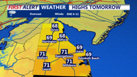
Delmarva will begin the holiday weekend with raw, breezy, and damp conditions today as spotty showers move across the peninsula. Temperatures will stay in the upper 50s to low 60s with east winds gusting up to 30 mph. A high rip current risk and cold ocean water will make beach and surf conditions dangerous today and tomorrow. Rain becomes steadier Saturday into Saturday night, with beneficial rainfall expected before showers taper Sunday. Memorial Day looks somewhat warmer, but showers may still linger at times.


The Delaware Office of Highway Safety, along with Delaware State Police and local law enforcement agencies, has postponed a Memorial Day weekend DUI checkpoint in Sussex County because of the expected bad weather.


Sussex County will stay cool and unsettled from early Friday through Saturday morning, with increasing rain chances and dangerous surf along the coast.


Sussex County faces cooler weather, increasing rain chances and dangerous rip currents from late Thursday night through late Friday night.


Delmarva’s record-breaking heatwave is over as a cold front stalls nearby, bringing cloudy, breezy and unsettled weather through Memorial Day. Periods of rain, cooler temperatures and elevated rip current risks are expected, though the rainfall will be beneficial amid ongoing severe drought conditions.


Sussex County will wake up cooler Thursday with clouds, northeast winds and scattered showers that may linger into early Friday.


Delmarva will see one more hot and humid day today, with inland highs in the mid 90s and a third straight 90-degree day marking a heat wave. A strong cold front will bring showers and isolated severe thunderstorms late this afternoon and evening, followed by a much cooler, unsettled pattern through the end of the week and Memorial Day weekend.

Strong storms may bring damaging wind gusts Wednesday evening before Sussex County turns sharply cooler with scattered showers Thursday.