


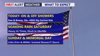


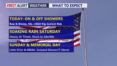
DELMARVA -- Today will feature raw conditions across the peninsula with spotty showers, cloudy skies, and temperatures mainly in the upper 50s to low 60s. East winds will increase through the day, with gusts up to 30 mph at times. A frontal boundary settling south of the region, along with high pressure building to the north across New England, will help keep cool onshore flow locked in across Delmarva.

Gloomy with on and off showers, gusts especially at the coast 30 mph+.
Light rain is expected at times today, especially as moisture begins to work back into the area. Rainfall through tonight will generally range from around 0.10 to 0.50 inches.
The beaches will also face dangerous conditions. A high risk of rip currents is in place today and tomorrow for the Delaware, Maryland, and Virginia coasts. Ocean water temperatures remain mainly in the 50s to low 60s, which can quickly lead to hypothermia or physical incapacitation for anyone suddenly immersed in the water. Beachgoers should avoid entering the surf and stay alert to posted warnings.
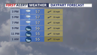
Tonight, temperatures will fall into the low 50s with spotty showers continuing.
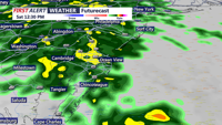
Saturday looks to be the wettest and chilliest day of the holiday weekend. East-northeast winds will increase to 15 to 20 mph, with gusts around 25 to 30 mph. Seas will build to 4 to 6 feet. These conditions will keep the rip current risk high along the coast.

Saturday soaker, periods of rain, could be heavy at times.
A developing area of low pressure tracking through the Ohio Valley and toward the eastern Great Lakes will help pull the stalled front back northward into the region. At the same time, cool high pressure will remain anchored to the north. This setup will create a chilly, cloudy, and rainy pattern across Delmarva, with steadier rain developing Saturday and Saturday night.
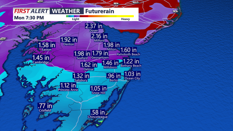
Some embedded heavier rain is possible, but the thunderstorm risk remains very low. Rainfall totals from Saturday into Sunday are expected to reach 1 to 2 inches, with overall totals of around 1.50 to 2.50 inches possible over the next three days. While the timing is not ideal for the holiday weekend, the rain will be beneficial as long-term drought conditions continue across the region.

Rainfall totals through Monday will be 1 to 2 inches, highest totals northern portions of the peninsula.
By Sunday, rain and showers should gradually taper off. Temperatures may recover slightly, but they will likely remain below average. Some drier conditions are possible by Sunday afternoon.
Memorial Day will be warmer, though not completely dry. The active pattern is expected to continue early next week, with a few showers still possible at times Monday. How warm it gets will depend on cloud cover and how widespread any showers become.
