


Light snow late Friday night is expected to be followed by high winds and life-threatening wind chills Saturday into early Sunday from Delaware’s beaches through Ocean City.
From
To


A cold stretch that turns downright harsh this weekend, with the biggest headline being dangerous wind chills and strong winds, not snow.


A key Bay-focused project in the bill is the Chesapeake Global Collaboratory, led by the University of Maryland Center for Environmental Science.

Light snow is expected to arrive late Friday in Sussex County, with minor accumulation possible before tapering to scattered snow showers or a brief squall early Saturday as colder air moves in.


Sussex County is expected to stay mostly calm through Friday evening, with light snow developing late and a much more dangerous wind-and-cold outbreak slated for the weekend.


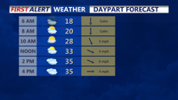
Delmarva stays sunny but cold today, then turns cloudier Friday ahead of a clipper and an arctic front. Snow looks minimal (if any, just a dusting), but a sharp temperature crash and powerful winds arrive Saturday—bringing dangerous wind chills into the single digits and potentially below zero.


Sussex County will see calm and cold conditions early Thursday through early Friday, with increasing clouds ahead of Friday night’s snow and Arctic front.

Light snow Friday evening will give way to possible snow squalls and dangerous cold by Saturday, with wind chills as low as -20°F.


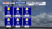
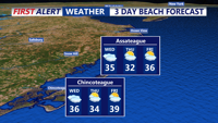
Colder-than-normal temperatures have settled across Delmarva, with highs ranging from the mid-30s to low 40s. The chill deepens by Thursday and into the weekend, as an arctic cold front approaches. While light snow is possible Friday, more impactful snow squalls and dangerously cold wind chills are expected Friday night into Saturday. Gusty winds behind the front may reach 50 mph, especially near the coast.

Snow exits early Wednesday with cold air entrenched across Sussex County through Thursday, setting the stage for a dangerous arctic blast this weekend.