


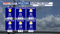


DELMARVA - Sussex County residents should brace for a wintry blast as an arctic cold front sweeps across the region late Friday into Saturday, bringing light snow, the risk of snow squalls, and dangerous wind chills plunging to -20°F.
We are now predicting widespread light snow beginning Friday evening, followed by potential snow squalls late Friday night. While accumulations are expected to be light — generally less than an inch — untreated roads could quickly become slick as temperatures remain well below freezing.
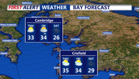
A Gale Watch has been issued for all adjacent marine waters late Friday night through Sunday morning, with potential for storm-force wind conditions.
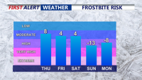
The true impact of this system comes in its wake. Once the arctic front passes, winds will intensify sharply, with gusts possibly exceeding 50 mph on Saturday. This will drive temperatures into the single digits, with wind chills dropping to -10 to -20 degrees by late Saturday night.
Motorists are urged to use caution Friday night into early Saturday morning, particularly if snow squalls materialize. These fast-moving bursts of snow can rapidly reduce visibility and create icy roads with little warning.
Cold weather advisories are expected, and residents are advised to prepare for extreme wind chills. Prolonged exposure could result in frostbite or hypothermia.
Conditions will gradually improve late Sunday into early next week as high pressure moves in and temperatures begin to moderate.