


High pressure builds into the region today, setting up a picture-perfect end to the week
From
To

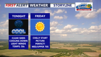
We're seeing clear skies, light winds, and cooler temperatures this evening. Make sure to grab a light jacket.

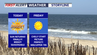
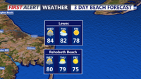
Sunny and drier weather returns to Delmarva today after a gloomy, humid stretch. A cold front has pushed through, bringing comfortable air, highs in the upper 70s to low 80s, and breezy northwest winds. Clear and cooler conditions settle in tonight, followed by a picture-perfect Friday with sunshine and highs in the upper 70s.

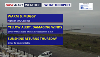
Delmarva has one more unsettled day ahead as a cold front approaches from the northwest. A Yellow Alert is in place for the threat of strong to severe thunderstorms this afternoon into early evening, with damaging wind gusts the main concern. Drier, more comfortable weather returns Thursday through the weekend.

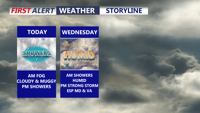
Showers and storms are expected early Wednesday through Wednesday evening before quieter weather returns by Thursday morning.

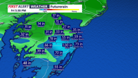
Showers and thunderstorms could bring heavy rain and gusty winds to Sussex County from late Tuesday night through Wednesday evening.

Delmarva will see some improvement today after morning showers and drizzle, but clouds and muggy conditions will continue as a stationary front lingers nearby. More showers are expected tonight into Wednesday, with a brief gusty thunderstorm possible late Wednesday before drier, more seasonable weather returns for the end of the week and weekend.

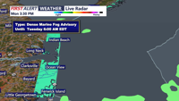
A mainly cloudy Tuesday will bring areas of morning fog, limited sunshine and a few showers before another unsettled stretch develops Tuesday night.

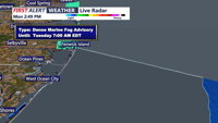
A high rip current risk and unsettled weather will continue before gradual improvement Tuesday.

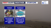
Delmarva will see a mild but unsettled Memorial Day with showers and a brief downpour or gusty thunderstorm possible late this afternoon into the evening. Highs will reach the mid 70s with southwest winds near 20 mph. Rainfall could total 1 to 2 inches in spots, and a high rip current risk continues along the beaches. More scattered showers remain possible Tuesday and Wednesday before drier weather returns late this week.