


Sussex County, Delaware, and Ocean City, Maryland, can expect a mild but breezy Friday evening with showers and a slight chance of thunder before drier, cooler conditions return Saturday.
From
To


Today officially began spring at 10:46 this morning, and Delmarva is enjoying mostly sunny skies, mild temperatures, and increasing southwest winds gusting 30 to 35 mph. Clouds will build this evening ahead of a quick-moving system bringing light showers overnight into early Saturday, with rainfall totals staying under a quarter inch and showers ending by around 8 a.m. Saturday. The weekend stays mild, with highs in the 50s and 60s Saturday and well into the 70s inland Sunday, before a stronger cold front arrives Monday with showers, gusty winds, and much colder air to start next week.


Sussex County, Del., will turn milder and breezier Friday, with gusty afternoon winds followed by light showers Friday night into early Saturday.


Sussex County, Del., will stay quiet late Thursday before milder air and gusty winds arrive Friday afternoon, ahead of light showers Friday night.


Delmarva turns noticeably warmer today with temperatures running about 10 to 13 degrees above yesterday’s levels. Mostly sunny skies will help highs reach the upper 40s to low 50s, followed by a mostly clear and chilly night with lows in the low to mid 30s. Spring officially arrives at 10:46 Friday morning, and even milder air is on the way with low 60s Friday, 60s Saturday, and some areas near 70 by Sunday before rain chances return late in the weekend.

Sussex County is expected to stay mainly dry from early Thursday morning through Friday morning as temperatures begin to warm.

A warming trend begins in Sussex County late Wednesday and continues through late Thursday with mainly dry conditions.


The Chincoteague Volunteer Fire Company announced the loss of Saltwater Cowboy and honorary member Edward Lewis, remembering him as a dedicated and selfless volunteer.


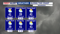
Today stays below average across Delmarva with partly sunny skies, highs in the upper 30s to low 40s, and a cold east-northeast wind off the ocean keeping conditions raw. Tonight turns partly cloudy with lows in the upper 20s to low 30s. The chill lingers Thursday before a warmer trend arrives Friday, the first day of spring, with highs near 60. Even warmer air builds in for the weekend, pushing temperatures into the 60s Saturday and low 70s inland Sunday before showers and cooler air return early next week.

Sussex County is forecast to stay cold and mainly dry from early Wednesday morning through early Thursday morning as the National Weather Service continues to cite a preliminary EF1 tornado near Ridgely, Md., from Monday night’s storms.