The Democratic Committee representing Delaware’s 4th Representative District has unanimously endorsed Gregg Lindner as its candidate for the state House seat in the 2026 election.
The Democratic Committee representing Delaware’s 4th Representative District has unanimously endorsed Gregg Lindner as its candidate for the state House seat in the 2026 election.
Sussex County, Del., will turn milder and breezier Friday, with gusty afternoon winds followed by light showers Friday night into early Saturday.
Delmarva turns noticeably warmer today with temperatures running about 10 to 13 degrees above yesterday’s levels. Mostly sunny skies will help highs reach the upper 40s to low 50s, followed by a mostly clear and chilly night with lows in the low to mid 30s. Spring officially arrives at 10:46 Friday morning, and even milder air is on the way with low 60s Friday, 60s Saturday, and some areas near 70 by Sunday before rain chances return late in the weekend.
Sussex County is expected to stay mainly dry from early Thursday morning through Friday morning as temperatures begin to warm.
A warming trend begins in Sussex County late Wednesday and continues through late Thursday with mainly dry conditions.
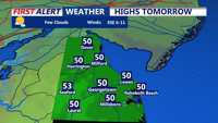
Today stays below average across Delmarva with partly sunny skies, highs in the upper 30s to low 40s, and a cold east-northeast wind off the ocean keeping conditions raw. Tonight turns partly cloudy with lows in the upper 20s to low 30s. The chill lingers Thursday before a warmer trend arrives Friday, the first day of spring, with highs near 60. Even warmer air builds in for the weekend, pushing temperatures into the 60s Saturday and low 70s inland Sunday before showers and cooler air return early next week.
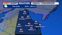
Sussex County is forecast to stay cold and mainly dry from early Wednesday morning through early Thursday morning as the National Weather Service continues to cite a preliminary EF1 tornado near Ridgely, Md., from Monday night’s storms.
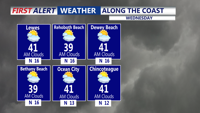
Sussex County is expected to stay cold and mostly dry from late Tuesday evening through late Wednesday evening, while the National Weather Service has preliminarily confirmed an EF1 tornado near Ridgely, Md., with peak winds of 100 mph.

Sussex County Council did not vote on a proposal for a temporary moratorium on certain cluster subdivisions in rural areas. Supporters believe it represents smart growth, while opponents fear worsening the housing shortage.
Delmarva turns sharply colder today with temperatures 20 to nearly 30 degrees below yesterday’s levels, gusty winds, and even the chance for a passing evening flurry. The chilly stretch continues through midweek before temperatures gradually rebound, leading to a much milder first weekend of spring with highs climbing into the 60s and 70s.