


Sussex County will stay cooler than normal Thursday with plenty of clouds and a chance for a brief shower.
From
To

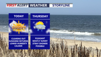
Cloudy, cooler conditions will continue across Sussex County through Thursday before quieter weather returns Thursday night.

Delmarva begins a stretch of calmer weather today, with sunshine, lower humidity and seasonable temperatures continuing into the weekend.

A quieter and less humid stretch begins today following Tuesday evening’s severe storms across Delmarva.

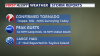
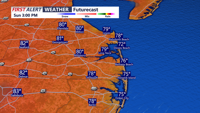
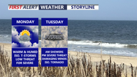
A warm and muggy Tuesday will bring multiple rounds of thunderstorms capable of producing damaging winds, torrential rainfall and localized flash flooding across Delmarva.

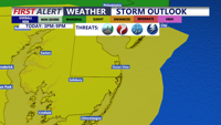
Be weather aware for the potential of severe weather later today.

Scattered strong storms are possible across Delmarva today, but Tuesday is expected to bring the greatest threat for severe weather and flash flooding.


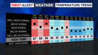
Delmarva will enjoy comfortable humidity, below-normal temperatures and mainly dry weather through the weekend before storm chances increase next week.


A breath of fresh air continues across Delmarva, with noticeably lower humidity, cooler temperatures, and plenty of sunshine today.

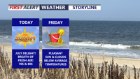
Refreshing air, sunshine and comfortable temperatures will give Delmarva one of its best stretches of summer weather through the weekend.