


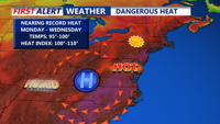
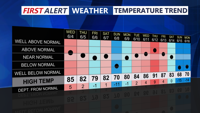
A stretch of dangerously hot weather is expected this week, as a ridge of high pressure over the western Atlantic pushes inland, fueling a heat wave across the region.
From
To


Starting Saturday, high pressure will usher in increasingly hot and humid weather across Delmarva. While Saturday remains manageable with highs near 90 and dewpoints in the mid-60s, the real danger sets in by Sunday with heat indices nearing triple digits. You should prepare for heat advisories and take safety precautions through at least Wednesday.


Sussex County will enjoy a mostly sunny and seasonably warm start Saturday, but heat and humidity will ramp up overnight into Sunday, marking the beginning of a dangerous heat wave.


Sussex County will enjoy a brief reprieve from the heat Friday night into Saturday, but steamy conditions and dangerous heat index values are expected to return by Sunday and continue into early next week.


Cooler, drier air arrives early Friday in Sussex County before temperatures and humidity climb again Saturday, with a risk of isolated severe storms.

Strong storms and a cold front Thursday evening will offer a brief break from the heat, but Sussex County will see rising temperatures and humidity again through the weekend into next week.


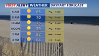
The intense heat continues on this final full day of spring. Temperatures this afternoon with be in the low to mid 90s, with heat indices over 100 in some spots. Be cautious in the heat the rest of today. The threat for severe weather increases this evening.


Severe storms Thursday afternoon give way to cooler, drier conditions by the weekend as a cold front clears Sussex County.

Hot and humid conditions continue into Thursday before a cold front brings the threat of strong storms and relief from the oppressive heat.


Sweltering conditions and the threat of severe storms will dominate Sussex County’s weather Wednesday and Thursday before relief arrives Friday.