


DELMARVA - A Bermuda high continues to influence the weather pattern across Sussex County, ushering in hot, humid air. Wednesday evening will remain warm and muggy, with isolated thunderstorms lingering before dissipating near sunset. A Severe Thunderstorm Watch is in effect through 7 p.m., as areas of strong storms push east across Delmarva. While conditions are expected to quiet overnight, patchy fog may form, especially in low-lying areas. Overnight lows settle into the upper 60s to low 70s.
THURSDAY – DANGEROUS HEAT & SEVERE STORM POTENTIAL
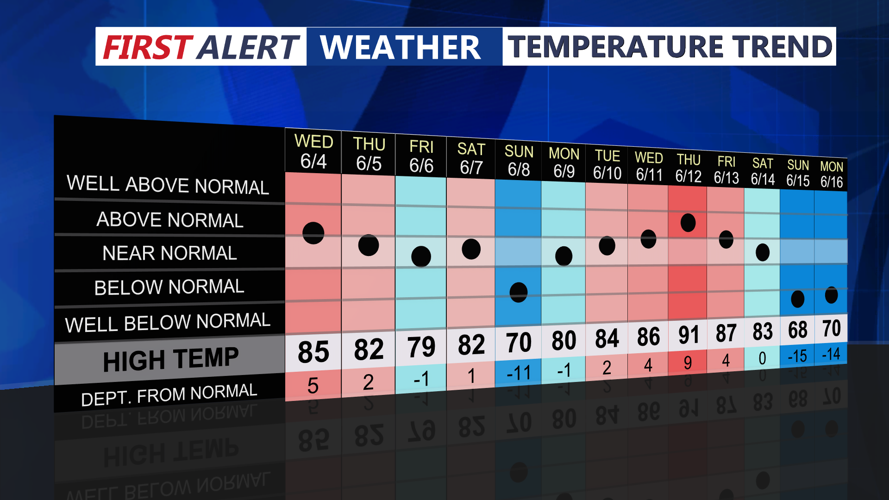
Thursday shapes up to be the hottest day of the week. Under mostly sunny skies and persistent southwesterly flow, high temperatures will soar into the upper 80s and low to mid-90s. When combined with dew points in the lower 70s, heat index values could approach or exceed 100 degrees, particularly in more urbanized zones. A Heat Advisory remains in effect until 8 p.m. Thursday.
In the afternoon and evening, attention turns to a cold front sweeping through from the west. With strong surface heating and abundant moisture in place, the atmosphere will be primed for thunderstorm development. Forecasters anticipate MLCAPE values near 2000 J/kg and moderate wind shear (30–35 kt), creating a setup favorable for strong to severe storms, particularly between 3 p.m. and 9 p.m.
Initial storm cells may develop into multicell clusters or isolated supercells, capable of producing damaging winds, hail, and heavy rainfall. An isolated tornado cannot be ruled out. Storms may evolve into a larger complex as they move east, increasing the threat for localized urban flooding and widespread wind damage. The Storm Prediction Center has placed the area under a SLIGHT risk (Level 2 of 5) for severe weather.
THURSDAY NIGHT – RELIEF ARRIVES
The cold front exits the region late Thursday night. Skies will begin to clear from west to east, with cooler and drier air filtering in. Overnight lows dip into the mid to upper 60s across Sussex County, bringing a noticeable change in air mass heading into Friday.
Looking Ahead: Cooler Friday, Heating Up Again This Weekend
High pressure builds in behind the front, bringing dry and sunny weather for Friday and Saturday. Temperatures will hover in the upper 70s to mid-80s Friday with more comfortable humidity levels. However, heat and humidity are expected to return Sunday into early next week, with potential heat index values nearing 100 degrees once again.
