


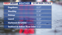
Sussex County, Delaware, and the Ocean City, Maryland, area can expect showers and isolated thunderstorms late Wednesday evening into early Thursday, followed by cooler, cloudy conditions Thursday.
From
To

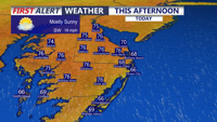
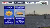
Delmarva will enjoy a mostly sunny and breezy day today with highs in the mid 70s and strong southerly gusts up to 35 to 40 mph. Showers arrive late this evening and continue overnight, with a few isolated thunderstorms possible, though severe weather is not expected. A brief unsettled stretch gives way to warmer, drier conditions by the weekend, with heat building into early next week.


DNREC is reminding fishermen that reservations will again be required beginning Saturday, May 23, for five drive-on surf fishing beaches during weekends and holidays through Labor Day.

Sussex County will start Wednesday mainly dry and mild before showers arrive by evening and continue into early Thursday morning.

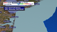
Sussex County stays mainly quiet late Tuesday night into much of Wednesday before showers and a few isolated thunderstorms move in Wednesday evening.

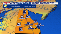
Delmarva will enjoy a sunny and comfortable day today with highs near 70 as high pressure settles in. Breezy and milder conditions arrive tonight into Wednesday, with temperatures climbing into the 70s before a cold front brings showers and a few possible thunderstorms Wednesday night into Thursday morning. After the system moves away, much warmer air builds in for the weekend and early next week, with widespread 80s and a few inland spots possibly reaching 90 by Monday.


The 8th Annual Back the Blue Caravan is underway across Sussex County, bringing community members together to support local law enforcement officers.

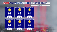
Sunny, mild and very dry weather is expected Tuesday across Sussex County, Delaware, and Ocean City, Maryland, before clouds increase early Wednesday ahead of the next rain system.

Dryer air will move into Sussex County, Delaware, and the Ocean City, Maryland, area late Monday night, setting up a sunny, mild Tuesday with low humidity and light winds

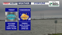
Delmarva will feel much cooler today, with temperatures running 25 to 30 degrees lower than yesterday. Scattered showers will taper off late this afternoon into the early evening, while gusty northeast winds make it feel raw. Sunshine returns Tuesday, followed by warmer, windier weather Wednesday with showers and a few thunderstorms possible. A drier and much warmer pattern is expected by the weekend, bringing a taste of summer with highs climbing into the upper 80s to low 90s.