


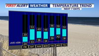
A cold start Friday gives way to sun and seasonably cold highs, then a crisp, mostly quiet Friday night into early Saturday.
From
To

Gusty northwest winds ease overnight as colder air settles in, leading to a mostly sunny but chilly Friday across Sussex County.

Strong northwest winds and a cooler air mass make Thursday feel sharply colder, with cold, mainly dry conditions lasting into early Friday morning.

Blustery northwest winds keep it feeling colder than the thermometer late Wednesday night through late Thursday night, with a brief cool-down settling in behind a midweek cold front.


Patchy freezing drizzle or a brief wintry mix early Wednesday may create isolated slick spots, followed by a colder stretch with a renewed refreeze risk Wednesday night into early Thursday.

A brief window for freezing drizzle late Tuesday night into early Wednesday could create isolated slick spots in Sussex County, especially on bridges and untreated roads.

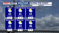
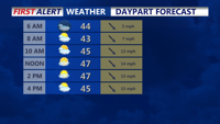
Sussex County, Delaware, starts Tuesday cold but calmer, then turns milder with increasing clouds and a chance of light rain or drizzle later Tuesday into Tuesday night.

Sussex County, Delaware, is expected to see a gradual warmup late Monday night into Tuesday, with a weak system bringing a chance of light precipitation Tuesday afternoon through Tuesday night. Any meaningful wintry icing risk is expected to stay well north, but a brief period of patchy slick spots can’t be ruled out if temperatures hover near freezing after dark.

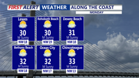
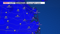
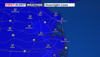
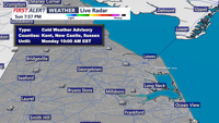
A Cold Weather Advisory covers Sussex County through Monday morning as wind chills stay near or below zero, with clouds increasing and temperatures moderating by early Tuesday

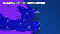
Bitter cold and subzero wind chills will hold on in Sussex County late Sunday night into Monday morning before temperatures rebound to the low 30s Monday afternoon.