


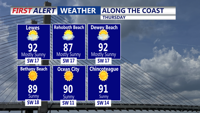

DELMARVA - Thursday starts warm and muggy across Sussex County, with early morning temperatures in the 70s and dew points already climbing. Under strong sunshine, high temperatures will rise quickly into the upper 80s to mid-90s by the afternoon. Combined with high humidity, heat index values will reach 95–100 degrees, prompting a Heat Advisory through 8 p.m. Thursday.
But it won’t just be the heat making headlines. A cold front will approach from the west Thursday afternoon, triggering strong to severe thunderstorms during the late day and early evening hours. The atmosphere will be primed for activity, with MLCAPE values near 2000 J/kg and wind shear supportive of multicell and isolated supercell development.
Forecasters warn of the potential for:
Damaging wind gusts
Heavy rainfall with localized urban flooding
Small hail
An isolated tornado risk
Storms are most likely between 3 p.m. and 9 p.m., though timing may vary slightly based on the front’s speed. Storms should push offshore or weaken significantly after nightfall.
THURSDAY NIGHT INTO FRIDAY: COLD FRONT CLEARS, COOLER AIR ARRIVES
By late Thursday night, the cold front will have moved through Sussex County, ushering in lower humidity and cooler air. Skies clear steadily overnight, with lows dipping into the mid to upper 60s.
Friday will be a welcome break from the heat. Expect sunny skies and highs in the upper 70s to low 80s with dew points near 60, making it feel much more comfortable. A gentle northwest breeze will keep conditions pleasant throughout the day. Friday night remains quiet and clear, with lows ranging from the upper 50s inland to the mid-60s near the coast.
SATURDAY (EARLY HOURS): CALM, DRY START TO THE WEEKEND
The weekend begins on a tranquil note. Early Saturday morning temperatures will be in the 60s under mostly clear skies. High pressure remains firmly in control, setting the stage for a dry, mostly sunny Saturday. Temperatures will rebound slightly into the low to mid-80s during the day, but humidity levels will stay manageable—at least for now.
As the weekend progresses, however, forecasters are watching for building heat and humidity to return by Sunday and early next week.