


DELMARVA -- The summer heat is back in full force across Delmarva starting Saturday, as a ridge of high pressure in the western Atlantic begins to dominate the region's weather pattern. The result: a prolonged stretch of increasingly hot and humid days, potentially bringing dangerous conditions by early next week.

First heatwave of the season starts this weekend into next week.
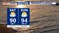
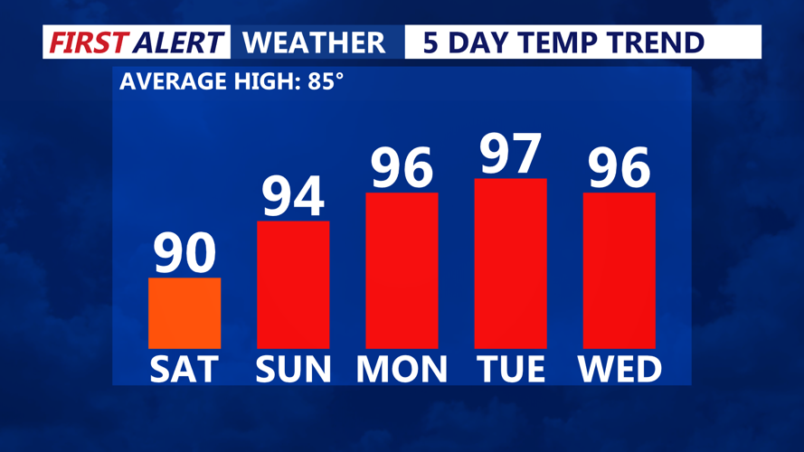
On Saturday, Delmarva will see mostly sunny skies and warming temperatures. Highs are expected to reach the upper 80s to near 90 degrees inland, while coastal communities stay in the low to mid-80s. Dewpoints will sit in the mid-60s, so while it will feel warm, heat indices won't be very high.
A subtle surface trough may pass through Saturday evening, bringing only some increased cloud cover. No precipitation or notable weather changes are anticipated with this feature.
By Sunday, temperatures are forecast to climb into the low to mid-90s across most inland areas of Delmarva. Even traditionally cooler areas like the coast could see highs near 90. Rising dewpoints into the low 70s will make for oppressive humidity, pushing heat index values into the upper 90s to near 100 for many locations away from the immediate shoreline.
With heat indices nearing critical thresholds, heat advisories are likely to be issued. Sunday night will offer little relief, as low temperatures are forecast to stay in the low to mid-70s across much of the region—and potentially the upper 70s in urban centers like Dover, Georgetown and Salisbury.

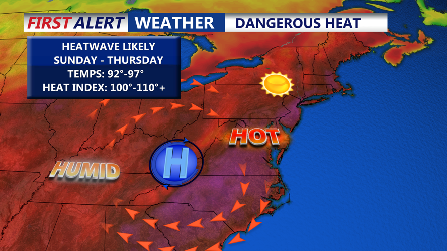
Giant ridge of high pressure builds across the eastern U.S. bringing a prolonged stretch of heat and humidity.
The most dangerous stretch of the heat wave is expected from Monday through Wednesday. The National Weather Service has issued an Extreme Heat Watch for parts of the Mid-Atlantic, including northern Delaware and areas along and north of the I-95 corridor. While the watch doesn't formally include all of Delmarva yet, the region is expected to experience widespread triple-digit heat indices 105-110+ during this period.
High temperatures could reach the upper 90s to around 100 degrees, particularly Monday and Tuesday, with dewpoints remaining elevated. Overnight lows may struggle to dip below 80 in some urban and inland areas, compounding heat stress and limiting nighttime recovery.
These conditions pose risks to public health, particularly for the elderly, children, outdoor workers, and those without access to air conditioning. Infrastructure stress and health system impacts are also possible.
While the upper-level ridge responsible for this heat is forecast to shift slightly south and west by Wednesday or Thursday, heat and humidity are expected to persist. Some cloud cover and the chance for isolated afternoon thunderstorms may help moderate temperatures slightly by Thursday, but but it's possible the heat could continue.
Residents on Delmarva are urged to:
Limit outdoor activities during peak afternoon hours.
Stay hydrated and wear lightweight clothing.
Check on vulnerable neighbors, family members and pets.
Never leave children or pets in parked vehicles.