Marijuana ordinances are frequently discussed among city and town councils in Sussex County. Here's a list of how towns and cities are handling the sale and manufacturing of recreational marijuana.
Marijuana ordinances are frequently discussed among city and town councils in Sussex County. Here's a list of how towns and cities are handling the sale and manufacturing of recreational marijuana.
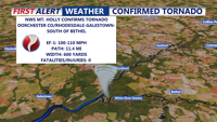
An EF-1 tornado with winds up to 110 mph struck Dorchester County, Md., and Sussex County, Del., Friday evening, damaging trees and homes along an 11.4-mile path from near Rhodesdale to south of Bethel. No injuries were reported. Sunday brought sunny, breezy conditions to Delmarva. A cold front moves in Sunday night, followed by a dry and pleasant start to the week. Rain returns Wednesday with cooler temperatures and unsettled weather through Saturday.

A 19-year-old male is recovering after being shot Thursday evening in Dover, as Delaware State Police investigate a shooting that ended with a car chase and four children arrested.
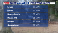
High winds continued to impact Delmarva on Sunday, bringing non-thunderstorm-related damage, including downed trees and roof damage in Laurel and Bethel, as gusts exceeded 60 mph. Peak wind speeds reached 67 mph in Lewes and Bethel, with Dewey Beach and Rehoboth Beach also experiencing strong gusts. A brief warm-up into the 60s accompanied rain, but a cold front is now bringing plunging temperatures, with lows in the 30s and wind chills in the teens and twenties by Presidents’ Day. Wind gusts of 40 to 55 mph will persist overnight. A developing coastal storm midweek could bring at least 6 inches of snow to much of Delmarva, with travel disruptions expected. The First Alert Weather team has issued Red Alerts for both the high winds and the potential winter storm.
Marijuana ordinances are frequently discussed among city and town councils in Sussex County. Here's a list of how towns and cities are handling the sale and manufacturing of recreational marijuana.