


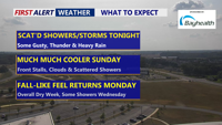
Scattered showers and thunderstorms will move across Delmarva Saturday evening, with the severe threat ending after 9 p.m. Some storms could still bring gusty winds, heavy rainfall, and localized flash flooding before overnight lows dip into the low to mid-60s. Much cooler air arrives Sunday as highs hold in the 60s, with a stalled front keeping scattered showers in the forecast. Skies will clear Sunday night, with lows in the mid-50s. Sunshine returns Monday with pleasant highs in the low to mid-70s, though clouds will increase Monday night as a weak coastal low approaches.
From
To

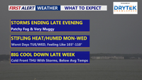
Sunday brought steamy conditions to Delmarva with highs hitting 91 degrees in Georgetown before afternoon storms rolled through. Storms could produce damaging winds and flash flooding before ending late tonight, the region faces a muggy night and foggy Monday morning. A hot stretch continues into midweek with heat indices reaching dangerous levels, followed by a cold front and potential storms before cooler, drier air arrives for next weekend.