


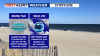
A stalled cold front south of Delmarva will bring sharply cooler, breezy conditions Monday, with highs only in the 70s under mostly cloudy skies with some showers possible. High pressure from the north will reinforce the cool pattern through midweek, while Hurricane Erin remains offshore but creates coastal hazards including high surf, rip currents, and possible flooding.
From
To


Delmarva will notice a big change in the weather starting Sunday night as a cold front sweeps across the region. The front is expected to pass from northwest to southeast late Sunday evening into the overnight hours, followed by a shift in winds from the southwest to the north and northeast. Low clouds are likely to form, with overnight lows dropping into the upper 60s to lower 70s by Monday morning.