site-logo
Facebook Instagram Threads X LinkedIn YouTube LinkedIn
  • Sign Up
  • Log In
  • Dashboard
  • Logout
    • My Account
    • Dashboard
    • Profile
    • Saved items
    • Logout
Home
  • About Us
  • Contact Us
  • Programming
  • Our Team
  • Submit a Tip
  • Newsletters
  • Apps
CoastTV Poll
News
  • Local News
  • Regional News
  • National News
  • International News
  • Feel Good
  • Police and Fire
  • Education
  • Politics
  • Business
  • Area Development
  • Environment
  • Health
  • Roadwork
  • Things to Do
  • Latest Newscasts
  • Featured Videos
  • Immigration
Weather
  • Latest Forecast
  • Weather Cameras
  • Closings
  • Phone
  • Weather101
Traffic
Features
  • Olympics
  • Cool Things
  • Coastal Connections
  • The Ties That Bind Us
  • Week in Review
  • Seaside Guides
  • Pet of the Day
  • Petey the Peacock
  • Salutes
  • Soaring Over the Shore
  • Umbrella Giveaway
  • Photo Booth
Delmarva Sports Network
CoastLife
Radio
  • WDEL
  • Coast Country 103.9 & 106.3
  • 93.5 The Beach
  • BIG 107.7
  • 102.5 WBOC
  • 107.1 The Duck
  • 100.9% Classic Country
  • 93.7 WSTW
  • WXCY 103.7 & 96.9
  • WCEI 96.7
  • 94.3 WINX
  • Watch Live
  • Apps
  • Contact Us
  • My Account
  • Sign Up
  • Log In
  • Dashboard
  • Logout
    • My Account
    • Dashboard
    • Profile
    • Saved items
    • Logout
Facebook Instagram Threads X LinkedIn YouTube LinkedIn
  • 33° Snow
    • Milton, DE (19968)

      Today

      Snow and gusty winds will lead to blizzard conditions at times. Low 29F. Winds NNW at 25 to 35 mph. Chance of snow 100%. 8 to 12 inches of snow expected. Winds could occasionally gust over 40 mph..

      Tonight

      Snow and gusty winds will lead to blizzard conditions at times. Low 29F. Winds NNW at 25 to 35 mph. Chance of snow 100%. 8 to 12 inches of snow expected. Winds could occasionally gust over 40 mph.

      Updated: February 22, 2026 @ 6:28 pm

    • Full Forecast
site-logo
Sunday, February 22, 2026
Watch Live

Newscast Schedule

View Programming Schedule
site-logo
  • 33°
  • Home
  • News
    • Local News
    • Regional News
    • National News
    • International News
    • Feel Good
    • Police and Fire
    • Education
    • Politics
    • Business
    • Area Development
    • Roadwork
    • Environment
    • Health
    • Things to Do
    • Latest Newscasts
    • Video
    • Immigration
  • Weather
    • Weather Cameras
    • Umbrellas
    • Closings
    • Weather Phone
    • Weather101
  • Traffic
  • Delmarva Sports Network
  • CoastLife
  • Features
    • Cool Things to Do
    • Coastal Connections
    • The Ties That Bind Us
    • Week in Review
    • Seaside Guides
    • Pet of the Day
    • Petey the Peacock
    • Salutes
    • Umbrella Giveaway
    • Photo Booth
    • Soaring Over the Shore
    • Olympics
  • Poll
  • About Us
    • About CoastTV
    • Bios
    • Contact Us
    • Newsletters
    • Apps
    • Channel Finder
    • Careers
    • Internships
  • Submit a tip

LEARN MORE

BLIZZARD

Download weather app

Broadcast Schedule

On air schedule

Weather Alert

Weather Alert

...COASTAL FLOOD WARNING REMAINS IN EFFECT UNTIL 5 AM EST
MONDAY...

* WHAT...One to two feet of inundation above ground level
expected in low-lying areas near shorelines and tidal
waterways.

* WHERE...Kent, Inland Sussex and Delaware Beaches.

* WHEN...Until 5 AM EST Monday.

* IMPACTS...At this level, widespread roadway flooding occurs in
coastal and bayside communities and along inland tidal
waterways. Many roads become impassable. Some damage to
vulnerable structures may begin to occur.

* ADDITIONAL DETAILS...Widespread minor to near moderate coastal
flooding likely with the Monday afternoon high tide. Back-bay
flooding may linger as far as Tuesday morning's high tide.
Further extensions will be warranted.

PRECAUTIONARY/PREPAREDNESS ACTIONS...

A Coastal Flood Warning means that moderate or major tidal
flooding is occurring or imminent. Be prepared for rising water
levels and take appropriate action to protect life and property.
Follow the recommendations of local emergency management
officials.

Do not drive your vehicle through flood waters. The water may be
deeper than you think it is. You will be putting yourself in
danger and your vehicle may be damaged, leading to costly
repairs.

Visit the National Water Prediction Service at
https://water.noaa.gov/wfo/phi for additional water level and
flood impact information for your local tide gauge.

&&

Time of high total tides are approximate to the nearest hour.

Murderkill River at Bowers Beach
MLLW Categories - Minor 6.6 ft, Moderate 7.6 ft, Major 8.6 ft
MHHW Categories - Minor 0.9 ft, Moderate 1.9 ft, Major 2.9 ft

Total      Total    Departure
Day/Time    Tide       Tide     from Norm   Flood
ft MLLW    ft MHHW       ft      Impact
--------  ---------  ---------  ---------  --------
23/01 AM     8.1        2.4        2.7     Moderate
23/01 PM     6.9        1.2        2.8      Minor
24/02 AM     6.7        1.0        1.4      Minor
24/02 PM     4.7       -1.0        0.9       None
25/03 AM     5.9        0.2        0.7       None
25/04 PM     3.9       -1.8        0.3       None

Delaware Bay at Lewes
MLLW Categories - Minor 6.0 ft, Moderate 7.0 ft, Major 8.0 ft
MHHW Categories - Minor 1.3 ft, Moderate 2.3 ft, Major 3.3 ft

Total      Total    Departure
Day/Time    Tide       Tide     from Norm   Flood
ft MLLW    ft MHHW       ft      Impact
--------  ---------  ---------  ---------  --------
23/12 AM     7.6        3.0        3.4     Moderate
23/01 PM     6.5        1.8        3.2      Minor
24/01 AM     5.8        1.2        1.6       None
24/02 PM     3.8       -0.9        0.8       None
25/02 AM     4.3       -0.4        0.2       None
25/03 PM     2.8       -1.9       -0.1       None

&&

Weather Alert

...STORM WARNING REMAINS IN EFFECT UNTIL 6 PM EST MONDAY...

* WHAT...North winds 30 to 40 kt with gusts up to 50 kt and
extremely rough waters.

* WHERE...Delaware Bay waters south of East Point NJ to
Slaughter Beach DE.

* WHEN...Until 6 PM EST Monday.

* IMPACTS...Storm force winds and hazardous seas will capsize or
damage vessels and reduce visibility.

* ADDITIONAL DETAILS...Winds are expected to reach storm force by
this evening.

PRECAUTIONARY/PREPAREDNESS ACTIONS...

Mariners should remain in port, alter course, and/or secure the
vessel for severe conditions.

&&

Weather Alert

...A MAJOR WINTER STORM WILL IMPACT THE REGION THROUGH MONDAY...

.A major winter storm will impact the region through Monday. Very
heavy snowfall and areas of blizzard conditions are expected. Rain
will change to all snow this afternoon and evening. The most severe
conditions and heaviest snowfall will occur tonight, with snow
gradually tapering off during the daytime Monday. Record breaking
snowfall totals are possible.

...BLIZZARD WARNING REMAINS IN EFFECT UNTIL 6 PM EST MONDAY...

* WHAT...Blizzard conditions. Total snow accumulations between 13
and 17 inches. Winds gusting as high as 55 mph.

* WHERE...Delaware Beaches and Inland Sussex Counties.

* WHEN...Until 6 PM EST Monday.

* IMPACTS...Travel could be very difficult to impossible. Widespread
blowing snow could significantly reduce visibility. The hazardous
conditions will impact the Monday morning and evening commutes.
Strong winds could cause tree damage and result in scattered power
outages.

* ADDITIONAL DETAILS...Snowfall rates could exceed 2 inches per
hour. Locally higher snowfall amounts and significant drifting of
snow possible. Some mixed precipitation possible this evening
before a change to all snow.

PRECAUTIONARY/PREPAREDNESS ACTIONS...

Travel should be restricted to emergencies only. If you must travel,
have a winter survival kit with you. If you get stranded, stay with
your vehicle. The latest road conditions for the state you are
calling from can be obtained by calling 5 1 1.

&&

Closings

Click here to view closings and delays

Advanced Search Close Search
From
To
Close Search
Update: No charges in death of Dorchester County K9 left in hot patrol car
News

Update: No charges in death of Dorchester County K9 left in hot patrol car

  • GRACE ECKERLE Alyssa Baker
  • Updated Sep 11, 2025

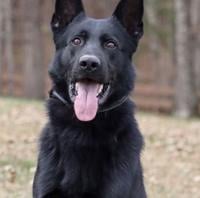
No charges are being recommended in connection with a Dorchester County K9 death after being left in a hot patrol car. The group that donated him says the sheriff’s office bypassed an autopsy that was required by contract. That group is now pursuing legal action. 


site-logo
Facebook Instagram Threads X BlueSky YouTube LinkedIn

    Sections

    • Home
    • News
    • Weather
    • CoastLife
    • Delmarva Sports Network
    • Telemundo Delmarva

    Services

    • Contact Us
    • Submit a tip
    • Search
    • CoastTV Poll
    • Newsletter
    • Careers
    • Internships

    Browser Compatibility

    Your browser is out of date and potentially vulnerable to security risks.
    We recommend switching to one of the following browsers:

    Microsoft Edge Google Chrome Firefox
    © Copyright 2026 CoastTV One The Sq, Milton, DE  | Terms of Use  | Privacy Policy
    Powered by BLOX Content Management System from BLOX Digital.