


A cold front will bring strong thunderstorms and potential flooding Tuesday night into Wednesday morning before drier, calmer conditions arrive later Wednesday and Thursday.
From
To

A strong cold front is expected to move through Delmarva late Monday, bringing the potential for strong to severe thunderstorms, heavy rainfall, and localized flooding. The worst of the weather is expected between 8 p.m. and 3 a.m. Tuesday. Cooler and drier conditions return Tuesday, but unsettled weather is likely to end the week.

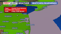
Chilly and increasingly cloudy today, followed by widespread minor coastal flooding starting with Thursday morning's high tide. A Coastal Flood Advisory remains in effect through Friday due to elevated astronomical tides from the full moon and persistent onshore winds. Rain is expected this evening into Friday morning, with up to a half an inch possible. By the weekend, drier air and milder temperatures in the 60s will settle in, but breezy conditions could persist.