


DELMARVA - Will have one more warm and breezy day Monday before a strong cold front pushes through the region late Monday night, bringing the risk of thunderstorms, heavy rain, and potentially severe weather.

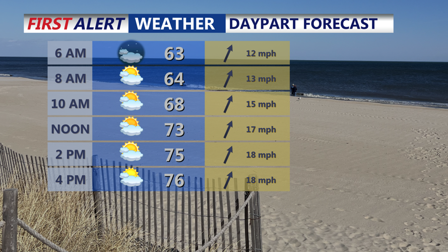
Expect another warm and breezy day ahead of a strong cold front.
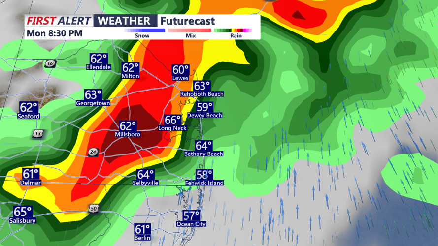
Highs Monday will climb into the upper 70s to near 80 degrees inland, with coastal areas holding in the 60s and 70s under mostly cloudy skies. Pre-frontal showers and thunderstorms may develop in the afternoon, but the greatest impacts are expected between 8 p.m. and 3 a.m. Tuesday as the cold front sweeps west to east across the peninsula.

Watching the possibility of severe thunderstorms pushing through this evening.
The Storm Prediction Center has placed the region under a Slight Risk for severe weather, citing damaging wind gusts as the primary threat. While instability is expected to be modest, strong upper-level dynamics and elevated wind shear may support the development of isolated tornadoes, although confidence in that scenario remains lower.
Rainfall totals of 0.75 to 1.25 inches are forecast across the region, with locally higher amounts possible. Despite ongoing drought conditions, forecasters are warning of the potential for localized flooding, particularly in urban and low-lying areas, due to the intensity of rainfall during the evening hours.
Following the frontal passage, temperatures will drop sharply overnight, with lows in the 40s across most of Delmarva. Winds will increase out of the northwest early Tuesday, gusting up to 30 mph before calming in the afternoon. Tuesday will be cooler but pleasant, with sunshine returning and highs in the upper 50s.
By Tuesday night, a cold Canadian air mass settles in, bringing widespread lows in the mid to upper 30s. While temperatures may not quite reach levels that would trigger frost or freeze alerts, the setup will be monitored closely, especially for areas where the growing season starts April 1.
Looking ahead, Wednesday begins with some sun before cloud cover increases. Another system arrives Thursday, keeping rain chances in the forecast into the weekend. Temperatures will climb into the 70s Thursday before cooling again Friday and Saturday, with highs generally in the upper 60s to low 70s.