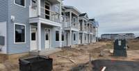
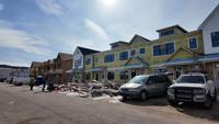
site-logo
Facebook Instagram Threads X LinkedIn YouTube LinkedIn
  • Sign Up
  • Log In
  • Dashboard
  • Logout
    • My Account
    • Dashboard
    • Profile
    • Saved items
    • Logout
Home
  • About Us
  • Contact Us
  • Programming
  • Our Team
  • Submit a Tip
  • Newsletters
  • Apps
Sussex County Growth
CoastTV Poll
News
  • Local News
  • Regional News
  • National News
  • International News
  • Feel Good
  • Police and Fire
  • Education
  • Politics
  • Business
  • Area Development
  • Environment
  • Health
  • Roadwork
  • Things to Do
  • Latest Newscasts
  • Featured Videos
  • Immigration
Weather
  • Latest Forecast
  • Weather Cameras
  • Closings
  • Phone
  • Weather101
Traffic
Features
  • Olympics
  • Cool Things
  • Coastal Connections
  • The Ties That Bind Us
  • Week in Review
  • Seaside Guides
  • Pet of the Day
  • Petey the Peacock
  • Salutes
  • Soaring Over the Shore
  • Umbrella Giveaway
  • Photo Booth
  • Lewes Fire Controversy
Delmarva Sports Network
CoastLife
Radio
  • WDEL
  • Coast Country 103.9 & 106.3
  • 93.5 The Beach
  • BIG 107.7
  • 102.5 WBOC
  • 107.1 The Duck
  • 100.9% Classic Country
  • 93.7 WSTW
  • WXCY 103.7 & 96.9
  • WCEI 96.7
  • 94.3 WINX
  • Watch Live
  • Apps
  • Contact Us
  • My Account
  • Sign Up
  • Log In
  • Dashboard
  • Logout
    • My Account
    • Dashboard
    • Profile
    • Saved items
    • Logout
Facebook Instagram Threads X LinkedIn YouTube LinkedIn
  • 34° Cloudy
    • Milton, DE (19968)

      Today

      Cloudy skies. A few flurries or snow showers possible. Temps nearly steady in the mid 30s. Winds light and variable..

      Tonight

      Cloudy. A few flurries or snow showers possible. Low 22F. W winds at less than 5 mph, increasing to 10 to 20 mph.

      Updated: February 6, 2026 @ 2:57 pm

    • Full Forecast
site-logo
Friday, February 6, 2026
Watch Live

Newscast Schedule

View Programming Schedule
site-logo
  • 34°
  • Home
  • News
    • Local News
    • Regional News
    • National News
    • International News
    • Feel Good
    • Police and Fire
    • Education
    • Politics
    • Business
    • Area Development
    • Roadwork
    • Environment
    • Health
    • Things to Do
    • Latest Newscasts
    • Video
    • Immigration
  • Weather
    • Weather Cameras
    • Umbrellas
    • Closings
    • Weather Phone
    • Weather101
  • Traffic
  • Delmarva Sports Network
  • CoastLife
  • Features
    • Cool Things to Do
    • Coastal Connections
    • The Ties That Bind Us
    • Week in Review
    • Seaside Guides
    • Pet of the Day
    • Petey the Peacock
    • Salutes
    • Umbrella Giveaway
    • Photo Booth
    • Soaring Over the Shore
    • Lewes Fire Controversy
    • Olympics
  • Sussex County Growth
  • Poll
  • About Us
    • About CoastTV
    • Bios
    • Contact Us
    • Newsletters
    • Apps
    • Channel Finder
    • Careers
    • Internships
  • Submit a tip
Broadcast Schedule

On air schedule

Weather Alert

Weather Alert

...STORM WARNING NOW IN EFFECT FROM 4 AM SATURDAY TO 4 AM EST
SUNDAY...
...HEAVY FREEZING SPRAY WARNING NOW IN EFFECT FROM 4 AM SATURDAY
TO 10 AM EST SUNDAY...

* WHAT...For the Storm Warning, northwest winds 30 to 40 kt with
gusts up to 50 kt and extremely rough waters expected. For the
Heavy Freezing Spray Warning, heavy freezing spray at a rate
of 2 cm per hour or greater expected, and may rapidly
accumulate on vessels.

* WHERE...Delaware Bay waters north of East Point NJ to
Slaughter Beach DE and Delaware Bay waters south of East Point
NJ to Slaughter Beach DE.

* WHEN...For the Storm Warning, from 4 AM Saturday to 4 AM EST
Sunday. For the Heavy Freezing Spray Warning, from 4 AM
Saturday to 10 AM EST Sunday.

* IMPACTS...Operating a vessel in heavy freezing spray is
hazardous. Freezing spray may render mechanical and electronic
components inoperative. Rapid ice accretion on decks and
superstructures may result in a catastrophic loss of
stability. Storm force winds and hazardous seas will capsize
or damage vessels and reduce visibility.

PRECAUTIONARY/PREPAREDNESS ACTIONS...

Mariners should prepare for dangerous accumulation of ice on
their vessel. If possible, remain in port, avoid the warning area
or conduct mitigation.

Mariners should remain in port, alter course, and/or secure the
vessel for severe conditions.

&&

Weather Alert

...HIGH WIND WARNING NOW IN EFFECT FROM 4 AM SATURDAY TO MIDNIGHT
EST SATURDAY NIGHT...
...EXTREME COLD WARNING REMAINS IN EFFECT FROM 6 AM SATURDAY TO NOON
EST SUNDAY...

* WHAT...For the High Wind Warning, northwest winds 25 to 35 mph
with gusts up to 60 mph expected. For the Extreme Cold Warning,
dangerously cold wind chills as low as 13 degrees below zero
expected.

* WHERE...Kent, New Castle, Delaware Beaches, and Inland Sussex
Counties.

* WHEN...For the High Wind Warning, from 4 AM Saturday to midnight
EST Saturday Night. For the Extreme Cold Warning, from 6 AM
Saturday to noon EST Sunday.

* IMPACTS...Damaging winds will blow down trees and power lines.
Widespread power outages are expected. Travel will be difficult,
especially for high profile vehicles. The cold wind chills as low
as 10 degrees below zero could result in hypothermia if
precautions are not taken.

* ADDITIONAL DETAILS...High winds potentially leading to power
outages combined with extremely cold conditions could be very
dangerous!

PRECAUTIONARY/PREPAREDNESS ACTIONS...

Remain in the lower levels of your home during the windstorm, and
avoid windows. Watch for falling debris and tree limbs. Use caution
if you must drive.

Secure outdoor objects.

Dress in layers including a hat, face mask, and gloves if you must
go outside.

If you do not have heat in your home or lack shelter, you can call
211 for assistance locating appropriate shelter from the cold.

&&

Closings

Click here to view closings and delays

Advanced Search Close Search
From
To
Close Search
Sussex County group seeks stories on workforce housing strain
News

Sussex County group seeks stories on workforce housing strain

  • Matthew Pencek
  • 12 hrs ago

The Sussex Economic Development Action Committee has launched a countywide focused on workforce housing.


site-logo
Facebook Instagram Threads X BlueSky YouTube LinkedIn

    Sections

    • Home
    • News
    • Weather
    • CoastLife
    • Delmarva Sports Network
    • Telemundo Delmarva

    Services

    • Contact Us
    • Submit a tip
    • Search
    • CoastTV Poll
    • Newsletter
    • Careers
    • Internships

    Browser Compatibility

    Your browser is out of date and potentially vulnerable to security risks.
    We recommend switching to one of the following browsers:

    Microsoft Edge Google Chrome Firefox
    © Copyright 2026 CoastTV One The Sq, Milton, DE  | Terms of Use  | Privacy Policy
    Powered by BLOX Content Management System from BLOX Digital.