


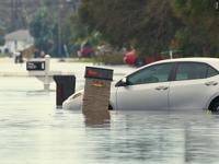

MARYLAND- Maryland coastal communities and locals now have a powerful new tool to help them understand and prepare for flooding. This month, the Maryland Department of Natural Resources released the Maryland Coastal Flood Explorer, an interactive online map that shows high tide flooding predictions, sea-level rise projections and historic flooding events across the state’s coastal areas.
Any person can visit the Flood Explorer, enter an address and see how flooding could impact their property or neighborhood today and decades into the future.
“Knowledge is our greatest defense, and the Flood Explorer puts the latest coastal flood science directly into the hands of the public,” said Natalie Snider, director of the Department's Watershed and Climate Services. “Understanding our flood risk is the first step to building resilience, whether it’s securing your own home with flood insurance or a living shoreline, or as a community through nature-based solutions and resilience projects.”
The tool lets users explore scenarios including:
- Current and future high-tide flooding
- Sea-level rise projections by decade through 2120
- Historic flooding from events such as Superstorm Sandy and Hurricane Isabel
Coastal flooding is an increasing hazard for Maryland communities. According to NASA’s flooding analysis, the average number of minor flood days each year in Annapolis has quadrupled since the 1970s. In response to this growing risk, the Department's Watershed and Climate Services led development of the Flood Explorer to make detailed flood visualizations accessible statewide.
The Department says the tool was created with help from the National Oceanic and Atmospheric Administration, Salisbury University’s Eastern Shore GIS Cooperative, University of Maryland Sea Grant and Sea Grant Extension. It is the first tool to feature Maryland-specific sea-level rise projections from the University of Maryland Center for Environmental Science.
Amanda Pollack of the Center for Watershed Protection said, “Having a visual, interactive platform will be a tremendous asset to the communities it serves. The ability to zoom in and assess impacts at the local level is especially useful. What really sets this tool apart is the inclusion of historic event visualizations in addition to sea level rise scenarios and high tide flooding data.”
Communities can use the Flood Explorer for planning efforts like updating hazard mitigation and nuisance flood plans, prioritizing adaptation projects, and public education. Locals can check how future flooding could affect local roads, schools, parks and other important places.
