


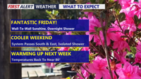
Delmarva will enjoy a pleasant Friday with highs ranging from the upper 50s and low 60s along the coast to the mid and upper 60s inland and around the Mid-Shore. Clouds increase late today as weak low pressure approaches, bringing only a brief shower or sprinkle overnight. The weekend starts mostly cloudy with a slight coastal rain chance Saturday, then turns sunnier and breezy Sunday before a major warmup sends temperatures into the 70s and near 80 by Tuesday.
From
To

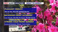
Today stays warm and sunny across Delmarva, but temperatures step down from yesterday’s record highs. Cooler air arrives near the coast Saturday as a backdoor front pushes in, while inland areas stay milder. Minor tidal flooding is expected along the Delaware coast and Delaware Bay Saturday evening into Saturday night, followed by showers, a few thunderstorms, and a sharp cool down late Saturday night into Sunday. Much colder air settles in early next week, with widespread frost or freeze conditions likely Monday night into Tuesday morning.

Beautiful end to a wild week, mild start to weekend, brief bout of wintry weather before big warm up
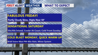
Delmarva stays quiet and seasonable today with upper 40s to low 50s, then warms quickly Saturday with inland highs near 60 (cooler at the beaches). An arctic front sweeps through late Saturday night, bringing a noticeably colder, breezy Sunday. Early next week, two separate systems could bring periods of wintry precipitation, followed by a likely transition to rain midweek. A bigger warm-up looks increasingly likely late next week.

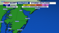
Showers and possible thunderstorms Saturday afternoon and evening, with the chance for strong wind gusts, hail and localized flooding. Conditions improve by Sunday, ushering in a stretch of dry and warmer weather through midweek, with summer-like temperatures returning by Wednesday.