


The stretch of dangerously hot weather is finally winding down after today. The ridge of high pressure responsible for the dangerous heat is beginning to break down. Temperatures are forecast to be in the 90s to around 100 again today, with heat index values between 100 and 106 degrees across most inland areas this afternoon and evening.
From
To


The stretch of dangerously hot weather continues through Wednesday, as a ridge of high pressure over the western Atlantic pushes inland, continuing the heat wave across the region. Temperatures are forecast to be in the 90s around 100, with heat index values between 100 and 110 degrees across most inland areas this afternoon and evening.


The National Weather Service has issued an Extreme Heat Warning for Sussex County, Delaware, as potentially record-breaking temperatures near or above 100 degrees threaten the region through early Wednesday.


A strong high-pressure system building over the Mid-Atlantic will bring dangerously hot and humid conditions to Delmarva starting Monday. Heat index values are forecast to soar between 100 to 110 degrees through Tuesday, with only slight relief expected by midweek. Heat Advisories remain in effect, with an Extreme Heat Watch issued for parts of southern Delmarva. Rain chances and cooler temperatures return by late week.


A stretch of dangerously hot weather is expected to unfold across Delmarva beginning Monday, driven by a high-pressure system expanding westward from the Atlantic. Heat indices could reach between 100 to 110 degrees through Tuesday, with little relief overnight. The heat will slightly ease later in the week, but scattered storms and increased humidity may follow.

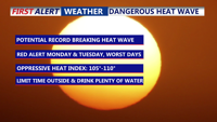
A dangerous, multi-day heat wave begins Sunday across the Delmarva Peninsula, with highs climbing into the upper 90s and heat index values reaching up to 110°F. The heat is expected to peak Monday and Tuesday, with potential to tie or break longstanding temperature records. Overnight relief will be minimal, and prolonged exposure could lead to serious health risks. While some moderation is expected later in the week, extreme heat remains a top concern through at least midweek.