


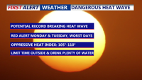


DELMARVA -- A prolonged and potentially record-setting heat wave is poised to blanket the Delmarva region starting Sunday, prompting health warnings and advisories across the peninsula.
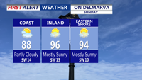
For Saturday night look for partly cloudy skies and lows in the low 70s, with humidity levels increasing. Sunday will be a sizzler as the heat and humidity really begin to take hold. Highs inland 91 to 96, at the coast 87 to 92. Feeling more like 100 with the heat index. An Air Quality Alert is in effect Sunday for all of Delaware, sensitive groups should limit outdoor time.

Temperatures soaring into the mid 90s, humidity on the rise making it feel closer to 100.
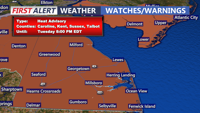
Heat Advisory begins Monday 8AM - 8PM Tuesday.

Heat Advisory in effect for Sussex and Kent Counties from 8AM Monday-8PM Tuesday.
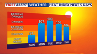
Georgetown last recorded a 100-degree day on July 21, 2019. Monday's forecast high may challenge the all-time record of 100 degrees set in 1988, while Tuesday’s record of 97 degrees from 2010 is also at risk.
The heat is driven by a strong ridge of high pressure stretching across the Ohio and Tennessee Valleys, expanding northeast into the mid-Atlantic. The National Weather Service warns that the heat will intensify through early next week, with temperatures in many inland communities surging into the mid to upper 90s. Heat index values — which factor in both heat and humidity — are expected to approach or exceed 105 degrees by Monday and Tuesday.

Feeling more like 105 to 110 Monday through Wednesday.
Overnight conditions will offer little relief, with lows in the mid to upper 70s. In some urban areas, overnight lows may not drop below 80 degrees.
Humidity levels are expected to be highest on Monday, contributing to dangerously high heat indices. Slightly drier air on Tuesday may allow for marginally lower apparent temperatures, but daytime highs will likely remain around 100 degrees.
By midweek, the ridge begins to weaken, and relief may start to arrive. Increased cloud cover and a slight uptick in rain chances could help reduce temperatures slightly on Wednesday and Thursday. Still, highs are expected to remain in the low to mid-90s midweek, with heat index values hovering near 100.
By Friday, temperatures may dip into the upper 80s to low 90s, with a higher chance of showers and thunderstorms as a cold front pushes southward.
Safety Tips:
Limit outdoor activity during the hottest parts of the day, seek shade or air-conditioned spaces, and stay well hydrated. Special care should be taken with children, the elderly, and pets.