


DELMARVA -- The stretch of dangerously hot weather is finally winding down after today. The ridge of high pressure responsible for the dangerous heat is beginning to break down. Temperatures are forecast to be in the 90s to around 100 again today, with heat index values between 100 and 106 degrees across most inland areas this afternoon and evening.

Another record will probably fall this afternoon with a forecasted high of 98. 96 is the record high in Georgetown for the date, set in 1952.

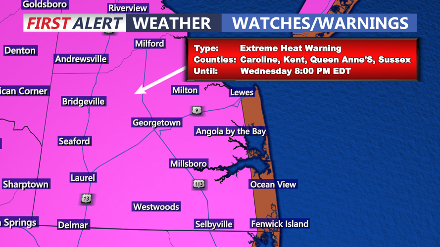
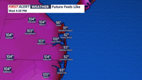
The high pressure ridge continues to weaken this afternoon. Although dew points may mix down slightly during peak heating, the heat and humidity combined will create sweltering conditions, particularly in southern portions of the peninsula. An Extreme Heat Warning continues until 8:00 PM this evening for interior Delmarva, with the exception of the immediate coast. The combination of temperature and humidity will push heat indices to dangerous levels. Some interior areas could see feels like temperatures as hot as 106 later this afternoon. A Heat Advisory is in effect for the immediate coast, where temperatures will be a few degrees cooler.

This will mark the fourth consecutive day of oppressive heat across Delmarva.
A change in the weather pattern arrives late in the week. As the upper-level ridge begins to erode, a surface trough will approach from the north. This will introduce increased cloud cover and the potential for scattered showers and thunderstorms, especially Thursday through the weekend. Some of these storms could be severe with damaging winds as the main threat.

On Thursday, temperatures are forecast to fall into the upper 80s to near 90 degrees, much closer to seasonal normals. Rain chances remain elevated into the weekend, marking a return to a more typical summer pattern, with highs primarily in the mid to upper 80s.