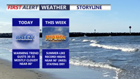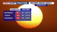
Delmarva’s early taste of summer continues today as temperatures climb into the upper 80s to low 90s under mostly sunny skies. After Georgetown tied its record high of 87 yesterday, more record highs are possible today with southwest winds at 10 to 15 mph. The warmth holds through Thursday before a weak front slips through late Thursday night, followed by a cooler but still mild Friday and Saturday. A stronger cold front arrives Sunday with scattered showers and thunderstorms possible late, then much cooler air settles in early next week with highs dropping into the 50s and 60s and even a chance for frost by Tuesday morning.