


Delmarva starts the week cooler and much drier behind a backdoor cold front, with mainly dry weather expected through Tuesday. Temperatures will quickly rebound by midweek, followed by dangerous heat and humidity Thursday into Friday, along with daily thunderstorm chances from Wednesday through the weekend.
From
To


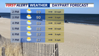
Delmarva will see a dry and gradually warming forecast beginning today, with inland temperatures in the 70s and cooler conditions along the coast. A high risk for dangerous rip currents continues from Delaware beaches south to Ocean City and Chincoteague. High pressure keeps the region dry through the end of the week, with some locations potentially reaching the low 90s by Friday and Saturday.

Sunday will be hot and humid across Delmarva with temperatures rising into the upper 80s and low 90s and heat index values between 100 and 104 degrees. A cold front approaching from the northwest could trigger isolated storms late in the day, some of which may become severe. After the front moves through, high pressure will bring more comfortable and dry conditions through Wednesday before heat and humidity return late in the week.