


DELMARVA -- Beginning the week on a cooler and much drier note after a backdoor cold front pushed through the region this morning. High pressure will keep conditions mainly dry through the middle of the week, with mostly sunny skies and gradually warming temperatures.

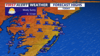
Mostly sunny and cooler with highs in the mid to upper 60s at the coast, low to mid 70s inland and mid-shore.
Today, easterly onshore flow will create a noticeable temperature difference across the peninsula. Coastal areas will stay cooler in the mid to upper 60s due to the nearby marine layer, while inland areas climb into the low to mid 70s. The mildest conditions are expected across the Mid-Shore, where highs may reach the mid to upper 70s under mostly sunny skies.

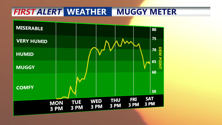
Humidity levels rise mid to late week, tropical like feel, dew points in the 70s.
Monday night will be cool and comfortable, with lows falling into the low to mid 50s. Some of the typically cooler inland spots may dip into the 40s.
The cool-down will not last long. By Tuesday, winds will shift more southerly, allowing warmer air to return to Delmarva. Highs are expected to climb back into the low to mid 80s with continued mostly sunny skies.
The second half of the week brings increasing concern for dangerous heat. A warm front is expected to move through the region on Wednesday, helping push temperatures and humidity higher. Thursday currently appears to have the highest chance for dangerous heat, with widespread highs in the 90s and heat index values near or above 100 degrees.

Heat indices 100 to 108 on Thursday creating some dangerous heat on Delmarva.
Friday will also remain hot and humid, though there is still some uncertainty in the forecast. Some guidance suggests the heat could continue to build, while other data points to more clouds and a nearby disturbance that could keep temperatures slightly lower than Thursday. Even so, highs in the 90s and elevated humidity are expected to keep heat impacts a concern.
Along with the heat, thunderstorm chances will increase from Wednesday through Sunday. Some storms may develop each afternoon due to daytime heating, the sea breeze, and local boundaries. Friday is one day to watch more closely, as some guidance is beginning to highlight the potential for stronger storms, though details remain uncertain.
Additional shower and thunderstorm chances are possible over the weekend as a pair of cold fronts approach Delmarva. The timing of those fronts remains unclear, but they could help lower the risk for extreme heat beyond Friday while keeping unsettled weather chances in the forecast.
