


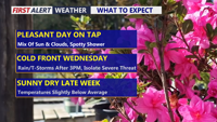
Delmarva will see a pleasant and mainly dry Tuesday with partly sunny skies and only a slight chance for an isolated shower or sprinkle. Temperatures will be mild inland, cooler along the coast, and partly cloudy skies continue tonight. Wednesday stays mild ahead of a strong cold front, with much-needed rain developing later in the day and continuing into early Thursday. A stronger thunderstorm cannot be ruled out, but the overall risk remains low.
From
To

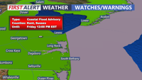
Chilly and increasingly cloudy today, followed by widespread minor coastal flooding starting with Thursday morning's high tide. A Coastal Flood Advisory remains in effect through Friday due to elevated astronomical tides from the full moon and persistent onshore winds. Rain is expected this evening into Friday morning, with up to a half an inch possible. By the weekend, drier air and milder temperatures in the 60s will settle in, but breezy conditions could persist.

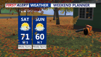
A cool and breezy weekend as high pressure builds over the region. Today will bring gusty northwest winds, with temperatures peaking in the upper 60s to near 70 degrees. A colder air mass moves in by Sunday, with daytime highs struggling to reach 60 degrees and widespread frost likely by Sunday night. The upcoming week will see a warming trend, with temperatures potentially reaching near-record highs by midweek under continued dry conditions.

Wet weather is expected tonight and early tomorrow morning in Delmarva, with a marginal risk for heavy downpours and thunderstorms, but conditions should improve by Thursday night as a front moves through, bringing cooler temperatures.

Friday will be a standout day with seasonable temperatures and mostly sunny skies, but the weekend brings increasing humidity and chances of showers and thunderstorms.