


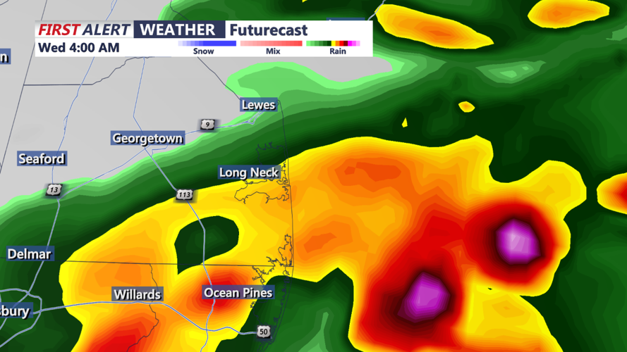


DELMARVA - An upper-level trough over the Great Lakes will bring continued wet weather to Delmarva tonight and early tomorrow morning. The region faces a marginal risk for excessive rainfall and potential heavy downpours. However, conditions are expected to improve by Thursday night as a front moves through, reducing moisture levels and the chance for showers and storms.
Tonight, the presence of the upper-level trough will maintain a southwesterly upper-level flow, keeping precipitable water values (PWATs) between 1.5 and 2.5 inches. This high moisture content will support convection, resulting in heavy downpours at times. Weak impulses are likely to move through Delmarva overnight and into the early morning hours, producing widespread showers and storms. As these shortwaves move out of the region, coverage may decrease, but isolated to scattered convection could persist, maintaining at least a chance of precipitation.
Due to the uncertainty in the coverage of heavy rainfall, the Weather Prediction Center (WPC) has issued a marginal risk (1 out of 4) for excessive rainfall in Delmarva for both tonight and tomorrow.
By Thursday into Thursday night, the upper-level trough will begin to progress eastward, pushing a front southward through Delmarva. This front will lower moisture levels, reducing the chances for showers and storms and bringing an end to the current wet pattern. Daytime temperatures will be near climate normals, with highs mainly in the mid-80s. Lows tonight will be warmer due to high moisture levels and potential cloud cover, primarily in the low to mid-70s. Following the front's passage on Thursday night, temperatures will cool, with lows mainly in the mid to upper 60s to near 70.
In conclusion, expect wet weather tonight and early tomorrow morning in Delmarva, with heavy downpours and thunderstorms possible. Conditions should improve by Thursday night as a front moves through, bringing cooler temperatures and reduced chances for precipitation. Stay tuned for further updates and take necessary precautions for potential heavy rainfall.
